IMAGES TAKEN NEAR TO
Glascoed Road, PONTYPOOL, NP4 0ND
Introduction
This page details the photographs taken nearby to Glascoed Road, NP4 0ND by members of the Geograph project.
The Geograph project started in 2005 with the aim of publishing, organising and preserving representative images for every square kilometre of Great Britain, Ireland and the Isle of Man.

There are currently over 7.5m images from over14,400 individuals and you can help contribute to the project by visiting https://www.geograph.org.uk
Image Map
Images are licensed for reuse under creativecommons.org/licenses/by-sa/2.0
Notes
- Clicking on the map will re-center to the selected point.
- The higher the marker number, the further away the image location is from the centre of the postcode.
Image Listing (84 Images Found)
Images are licensed for reuse under creativecommons.org/licenses/by-sa/2.0
Image
Details
Distance
1
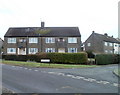
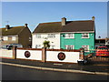
Glosters Parade, New Inn, Pontypool
Houses on the corner of Glosters Parade, viewed across Festival Crescent.
Image: © Jaggery
Taken: 21 Jan 2011
0.03 miles
2
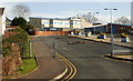
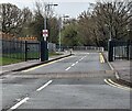
New Inn Primary School
New Inn Primary School was formed in 2006 by the amalgamation of Greenlawn Junior School and New Inn Infants School. It is the largest primary school campus in Torfaen with nearly 600 pupils in years 1 to 6 and about 60 in the nursery unit. The school's main entrance, shown here, is from an access road from Golf Road. There is also pedestrian access from Hillcrest.
Image: © Jaggery
Taken: 17 Jan 2010
0.03 miles
3
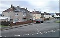
Glascoed Road, New Inn, Pontypool
Houses at the southern end of Glascoed Road, viewed across Festival Crescent.
Image: © Jaggery
Taken: 21 Jan 2011
0.09 miles
4
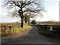
Entrance to Trychywmad Farm, New Inn
Viewed from Jerusalem Lane.
Image: © Jaggery
Taken: 17 Jan 2010
0.12 miles
5
Wheeled wall, Jerusalem Lane, New Inn
An eye-catching wall with embedded wheels, on Jerusalem Lane.
Image: © Jaggery
Taken: 17 Jan 2010
0.12 miles
6
North end of Festival Crescent, New Inn
Festival Crescent heads away from Jerusalem Lane. It loops around the west of Jerusalem Lane and rejoins it about 250 metres south of here. http://www.geograph.org.uk/photo/1677169
Image: © Jaggery
Taken: 17 Jan 2010
0.12 miles
7
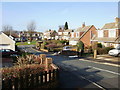
Hillcrest, New Inn
Looking from Jerusalem Lane along houses on Hillcrest towards Ambryn Road.
Image: © Jaggery
Taken: 17 Jan 2010
0.12 miles
8
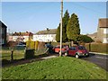
Horse riding, Golf Road, New Inn
Three young riders and their horses travel along Golf Road, approaching the turning for Pine Tree Road. http://www.geograph.org.uk/photo/1761437
Image: © Jaggery
Taken: 17 Jan 2010
0.12 miles
9
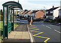
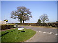
Access road to New Inn Primary School, Torfaen
From Golf Road. The sign on the left indicates a 5 mph speed limit.
Image: © Jaggery
Taken: 5 Apr 2024
0.13 miles
10
Junction of Festival Crescent with Jerusalem Lane, New Inn
Image: © John Lord
Taken: 2 Mar 2011
0.13 miles