IMAGES TAKEN NEAR TO
Chester Close, PONTYPOOL, NP4 0LW
Introduction
This page details the photographs taken nearby to Chester Close, NP4 0LW by members of the Geograph project.
The Geograph project started in 2005 with the aim of publishing, organising and preserving representative images for every square kilometre of Great Britain, Ireland and the Isle of Man.

There are currently over 7.5m images from over14,400 individuals and you can help contribute to the project by visiting https://www.geograph.org.uk
Image Map
Images are licensed for reuse under creativecommons.org/licenses/by-sa/2.0
Notes
- Clicking on the map will re-center to the selected point.
- The higher the marker number, the further away the image location is from the centre of the postcode.
Image Listing (20 Images Found)
Images are licensed for reuse under creativecommons.org/licenses/by-sa/2.0
Image
Details
Distance
1
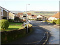
Looking along Chester Close, New Inn
Chester Close has several branches to left and right from the central road. The exit from Chester Close is on to Jerusalem Lane.
Image: © Jaggery
Taken: 17 Jan 2010
0.06 miles
2
Chester Close houses, New Inn, Torfaen
Vehicles access Chester Close from Jerusalem Lane.
Walkers can also reach Chester Close via a footpath from Golf Road.
Image: © Jaggery
Taken: 7 Apr 2024
0.09 miles
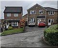
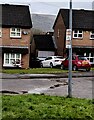
3
Detached houses, Chester Close, New Inn, Torfaen
The grey cabinet is a National Grid electricity substation. https://www.geograph.org.uk/photo/7743985
Image: © Jaggery
Taken: 7 Apr 2024
0.10 miles
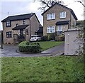
4
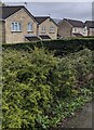
Houses behind a hedge, Chester Close, New Inn, Torfaen
Viewed from the path descending from Golf Road.
Image: © Jaggery
Taken: 7 Apr 2024
0.11 miles
5
Cold Calling Control Zone notice on a Chester Close lamppost, New Inn, Torfaen
Cold calling is the contacting by businesses or their agents of people
thought to be potential customers, without the contact having been prearranged.
Image: © Jaggery
Taken: 7 Apr 2024
0.11 miles
6
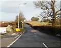
Junction of Jerusalem Lane and Chester Close, New Inn
Beyond the Chester Close junction, Jerusalem Lane narrows from a 2-lane suburban road into a 1-lane country road, and the 30 mph speed limit ends.
Image: © Jaggery
Taken: 17 Jan 2010
0.11 miles
7
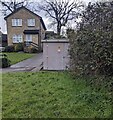
Grey cabinet, Chester Close, New Inn, Torfaen
The cabinet is a National Grid electricity substation. Its identifier is S/S 536569
Image: © Jaggery
Taken: 7 Apr 2024
0.11 miles
8
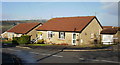
Chester Close, New Inn
Houses on the north side of Chester Close, near the Jerusalem Road junction.
Image: © Jaggery
Taken: 17 Jan 2010
0.11 miles
9
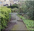
Metal barriers across a footpath, New Inn, Torfaen
Preventing vehicular misuse of the path https://www.geograph.org.uk/photo/7743320 descending from Golf Road.
Chester Close houses are in the background.
Image: © Jaggery
Taken: 7 Apr 2024
0.13 miles
10
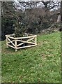
Small Christmas tree in a wooden enclosure, New Inn, Torfaen
On the green on the north side of Golf Road in December 2024.
A Nativity scene https://www.geograph.org.uk/photo/7950263 is nearby.
Image: © Jaggery
Taken: 31 Dec 2024
0.13 miles