IMAGES TAKEN NEAR TO
Mamhilad Technology Park, PONTYPOOL, NP4 0JJ
Introduction
This page details the photographs taken nearby to Mamhilad Technology Park, NP4 0JJ by members of the Geograph project.
The Geograph project started in 2005 with the aim of publishing, organising and preserving representative images for every square kilometre of Great Britain, Ireland and the Isle of Man.

There are currently over 7.5m images from over14,400 individuals and you can help contribute to the project by visiting https://www.geograph.org.uk
Image Map
Images are licensed for reuse under creativecommons.org/licenses/by-sa/2.0
Notes
- Clicking on the map will re-center to the selected point.
- The higher the marker number, the further away the image location is from the centre of the postcode.
Image Listing (25 Images Found)
Images are licensed for reuse under creativecommons.org/licenses/by-sa/2.0
Image
Details
Distance
1
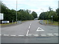
Entrance to Mamhilad Technology Park
The technology park is on the east side of Old Abergavenny Road, opposite Mamhilad
Park Estate. http://www.geograph.org.uk/photo/3045540
Among the occupiers of Mamhilad Technology Park at the date of this view were
Monmouthshire Housing headquarters.
Carlisle Brake Products (UK) Ltd.
CMF (Composite Metal Flooring).
Dawnus Construction Limited.
Ultrapharm bakers and
Lifestyle Healthcare Ltd.
Image: © Jaggery
Taken: 1 Jul 2011
0.06 miles

3

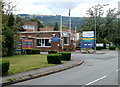
Mamhilad Park Estate, Main Entrance
The main entrance. Once part of BNS (British Nylon Spinners), later ICI and Du Pont.
Image: © Jeremy Bolwell
Taken: 25 Mar 2012
0.14 miles
4
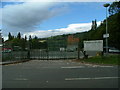
Main entrance to Mamhilad Park Estate
Viewed from Old Abergavenny Road.
One notice states that all visitors must report to security. Another notice states that all delivery drivers must report to the security hut before entry.
Mamhilad Park Estate occupies the site of the former British Nylon Spinners, later renamed ICI Fibres. An earlier use of this site was during the Second World War, when a camp of huts provided accommodation for workers at a nearby Royal Ordnance factory.
Image: © Jaggery
Taken: 1 Jul 2011
0.15 miles
5
Mamhilad Park Estate (rear entrance)
This is the rear entrance to Mamhilad Park Estate, a business park.
Image: © Nick Mutton 01329 000000
Taken: 2 Sep 2007
0.15 miles
6

Car park, Eastway, Mamhilad Park Estate
Private parking on the east side of Eastway; the low brick building beyond is the gatehouse on Old Abergavenny Road.
Image: © M J Roscoe
Taken: 2 Mar 2021
0.15 miles
7
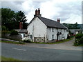
Monachty farmhouse, Mamhilad
The farmhouse is at the southern edge of the farm, alongside Usk Road (A4042).
Image: © Jaggery
Taken: 1 Jul 2011
0.16 miles
8
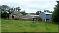
Monachty Farm buildings, Mamhilad
Viewed from Usk Road (A4042).
Image: © Jaggery
Taken: 1 Jul 2011
0.16 miles
9

Office block frontage at Mamhilad
Built in the 1950's and still in use, but not by the original occupier.
Image: © Jeremy Bolwell
Taken: 25 Mar 2012
0.16 miles
10

Offices and factory at Mamhilad
Once part of the massive BNS (British Nylon Spinners) plant.
Image: © Jeremy Bolwell
Taken: 25 Mar 2012
0.18 miles