IMAGES TAKEN NEAR TO
Cwmoody, PONTYPOOL, NP4 0JA
Introduction
This page details the photographs taken nearby to NP4 0JA by members of the Geograph project.
The Geograph project started in 2005 with the aim of publishing, organising and preserving representative images for every square kilometre of Great Britain, Ireland and the Isle of Man.

There are currently over 7.5m images from over14,400 individuals and you can help contribute to the project by visiting https://www.geograph.org.uk
Image Map
Images are licensed for reuse under creativecommons.org/licenses/by-sa/2.0
Notes
- Clicking on the map will re-center to the selected point.
- The higher the marker number, the further away the image location is from the centre of the postcode.
Image Listing (23 Images Found)
Images are licensed for reuse under creativecommons.org/licenses/by-sa/2.0
Image
Details
Distance
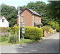
1
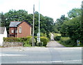
Glen View, Cwmoody near Pontypool
Viewed across Usk Road (A4042). Glen View is the most northerly of a small group of houses in Cwmoody.
Image: © Jaggery
Taken: 1 Jul 2011
0.03 miles
2
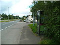
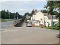
Looking along the A4042(T) with phone box
Looking back towards Mamhilad.
Image: © Nick Mutton 01329 000000
Taken: 2 Sep 2007
0.08 miles
3
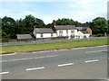
Cwmoody houses near Pontypool
A small group of houses viewed across Usk Road (A4042).
Image: © Jaggery
Taken: 1 Jul 2011
0.09 miles
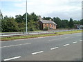
4
Cwmoody House near Pontypool
Detached house on the east side of Usk Road (A4042), opposite an entrance http://www.geograph.org.uk/photo/2486262 to Usk Valley Business Park.
Image: © Jaggery
Taken: 1 Jul 2011
0.09 miles
5
Lane to Ty-mawr Farm from the A4042, Cwmoody
The lane heads away from Usk Road (A4042) past Cwmoody House. http://www.geograph.org.uk/photo/2486269
Image: © Jaggery
Taken: 1 Jul 2011
0.09 miles
6
Cwmoody houses near Pontypool
Located on the side of Usk Road (A4042) to the NE of Pontypool.
Image: © Jaggery
Taken: 1 Jul 2011
0.09 miles
7
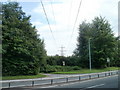
Power lines across the A4042 near the Wain-y-Clare pub
Power lines cross a pub access lane http://www.geograph.org.uk/photo/2486213 and Usk Road (A4042).
Image: © Jaggery
Taken: 1 Jul 2011
0.11 miles
8
Wain-y-Clare access lane
Viewed across Usk Road (A4042). The lane leads to the Wain-y-Clare pub. http://www.geograph.org.uk/photo/2486208
Image: © Jaggery
Taken: 1 Jul 2011
0.11 miles
9
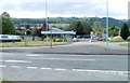
Entrance to Usk Valley Business Park near Pontypool
Viewed across Usk Road (A4042). Originally built for a pharmaceutical company, the business park now provides a range of manufacturing and laboratory facilities, storage and administrative space.
Image: © Jaggery
Taken: 1 Jul 2011
0.12 miles
10
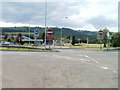
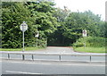
Central reserve gap closed, Cwmoody near Pontypool
The No Entry sign has explanatory text underneath. The location is the A4042 (Usk Road) in Cwmoody, to the NE of Pontypool. Viewed from the edge of Cwmoody House. http://www.geograph.org.uk/photo/2486269
On the opposite side of road is an entrance http://www.geograph.org.uk/photo/2486262 to Usk Valley Business Park.
Image: © Jaggery
Taken: 1 Jul 2011
0.12 miles