IMAGES TAKEN NEAR TO
Clos Melin Coed, PONTYPOOL, NP4 0HY
Introduction
This page details the photographs taken nearby to Clos Melin Coed, NP4 0HY by members of the Geograph project.
The Geograph project started in 2005 with the aim of publishing, organising and preserving representative images for every square kilometre of Great Britain, Ireland and the Isle of Man.

There are currently over 7.5m images from over14,400 individuals and you can help contribute to the project by visiting https://www.geograph.org.uk
Image Map
Images are licensed for reuse under creativecommons.org/licenses/by-sa/2.0
Notes
- Clicking on the map will re-center to the selected point.
- The higher the marker number, the further away the image location is from the centre of the postcode.
Image Listing (42 Images Found)
Images are licensed for reuse under creativecommons.org/licenses/by-sa/2.0
Image
Details
Distance
1
The Sawmill, Little Mill
The Sawmill is a recently-built house on the site of a demolished sawmill. This site has had a variety of uses in the past two centuries. Before the sawmill, in the early 19th century, it was a blacksmith's shop, which developed into a carriage shop where local wheelwrights learned their trade.
Image: © Jaggery
Taken: 26 Oct 2012
0.02 miles
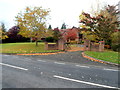
2
Towards a bend in Cae Melin, Little Mill, Monmouthshire
Viewed from the corner of the A472 Berthon Road.
Image: © Jaggery
Taken: 23 May 2021
0.03 miles
3
ARAF/SLOW on the A472, Little Mill, Monmouthshire
Welsh/English text painted on the main road through Little Mill.
A Your Speed indicator is on the lamppost on the left.
Image: © Jaggery
Taken: 23 May 2021
0.05 miles
4
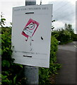
Keep Your Children Safe notice, Little Mill, Monmouthshire
Showing KEEP YOUR CHILDREN SAFE - GIVE DOG FOULING THE RED CARD, the sign is on a lamppost alongside the A472 near the Cae Melin junction.
Image: © Jaggery
Taken: 23 May 2021
0.05 miles
5
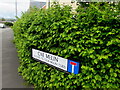
Name sign in a Little Mill hedge, Monmouthshire
The sign facing the A472 Berthon Road shows that Cae Melin https://www.geograph.org.uk/photo/6849509 leads to Clos Melin Coed.
Image: © Jaggery
Taken: 23 May 2021
0.05 miles
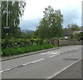
6
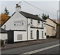
Halfway House viewed from the SW, Little Mill
Viewed across the A472, the main road through Little Mill.
At the late October 2012 date of this view, an estate agents' board
on the wall offers the freehold for sale at £200,000.
http://www.geograph.org.uk/photo/3196978 to a view from the SE.
Image: © Jaggery
Taken: 26 Oct 2012
0.05 miles
7
North along Cae Melin, Little Mill, Monmouthshire
From the A472 Berthon Road, Cae Melin leads to Clos Melin Coed.
Image: © Jaggery
Taken: 23 May 2021
0.05 miles

9
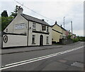
Village pub, Little Mill, Monmouthshire
The Halfway House is on the north side of the A472 Berthon Road, the main road through Little Mill.
Image: © Jaggery
Taken: 23 May 2021
0.05 miles
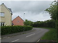
10
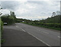
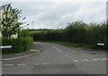
Junction of Berthon Road and Cae Melin, Little Mill, Monmouthshire
From the left, Cae Melin joins the A472 Berthon Road. Ahead for Usk via Monkswood.
Image: © Jaggery
Taken: 23 May 2021
0.06 miles