IMAGES TAKEN NEAR TO
Little Mill, PONTYPOOL, NP4 0HQ
Introduction
This page details the photographs taken nearby to NP4 0HQ by members of the Geograph project.
The Geograph project started in 2005 with the aim of publishing, organising and preserving representative images for every square kilometre of Great Britain, Ireland and the Isle of Man.

There are currently over 7.5m images from over14,400 individuals and you can help contribute to the project by visiting https://www.geograph.org.uk
Image Map
Images are licensed for reuse under creativecommons.org/licenses/by-sa/2.0
Notes
- Clicking on the map will re-center to the selected point.
- The higher the marker number, the further away the image location is from the centre of the postcode.
Image Listing (5 Images Found)
Images are licensed for reuse under creativecommons.org/licenses/by-sa/2.0
Image
Details
Distance
4
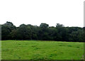
Grazing towards woodland
South of Penperlleni.
Image: © JThomas
Taken: 11 Aug 2021
0.25 miles
5
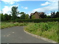
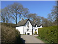
Saw Mill House (rear view)
This is the view view of Saw Mill House and turning area.
Image: © Nick Mutton 01329 000000
Taken: 2 Sep 2007
0.25 miles