IMAGES TAKEN NEAR TO
The Stepping Stones, PONTYPOOL, NP4 0BP
Introduction
This page details the photographs taken nearby to The Stepping Stones, NP4 0BP by members of the Geograph project.
The Geograph project started in 2005 with the aim of publishing, organising and preserving representative images for every square kilometre of Great Britain, Ireland and the Isle of Man.

There are currently over 7.5m images from over14,400 individuals and you can help contribute to the project by visiting https://www.geograph.org.uk
Image Map
Images are licensed for reuse under creativecommons.org/licenses/by-sa/2.0
Notes
- Clicking on the map will re-center to the selected point.
- The higher the marker number, the further away the image location is from the centre of the postcode.
Image Listing (125 Images Found)
Images are licensed for reuse under creativecommons.org/licenses/by-sa/2.0
Image
Details
Distance
1
Up Highfield, Penperlleni
Highfield ascends from the west side of Capel Ed Lane.
Image: © Jaggery
Taken: 27 Mar 2022
0.05 miles
2
Houses, trees and blue sky, Capel Ed Lane, Penperlleni
The house on the left is on the corner of Meadowbank.
Image: © Jaggery
Taken: 27 Mar 2022
0.08 miles
3
Street name in a hedge, Penperlleni
The Longhouse Barn name sign is in the hedge at the corner of Capel Ed Lane.
Image: © Jaggery
Taken: 27 Mar 2022
0.09 miles
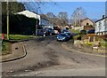
4

Dark red van, Capel Ed Lane, Penperlleni
Text on the van in March 2022 includes
"RGH maintenance" and "Russ Howitt Decorating Services".
The Highfield junction is on the right.
Image: © Jaggery
Taken: 27 Mar 2022
0.09 miles
5
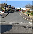
Junction of Highfield and Capel Ed Lane, Penperlleni
Viewed across Capel Ed Lane.
Image: © Jaggery
Taken: 27 Mar 2022
0.09 miles
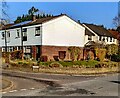
6
Up Meadowbank, Penperlleni
Meadowbank ascends from Capel Ed Lane.
Image: © Jaggery
Taken: 27 Mar 2022
0.09 miles
7
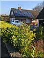
Rooftop solar panels, Capel Ed Lane, Penperlleni
Optimally located on a south facing roof.
Image: © Jaggery
Taken: 27 Mar 2022
0.09 miles
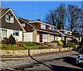
8
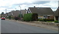
Long-roofed houses, Penperlleni
The houses are on the east side of Capel Ed Lane.
Image: © Jaggery
Taken: 30 Jun 2011
0.10 miles
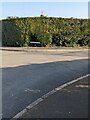
9
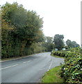
A4042 north of Penperlleni
Looking along the A4042, past a lay-by, in the direction of Penperlleni. http://www.geograph.org.uk/photo/261374
Image: © Jaggery
Taken: 22 Sep 2011
0.10 miles
10
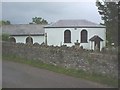
Capel Ed, Penperlleni
On Capel Ed Lane in the Penperlleni area of Goetre (AKA Goytre to some locals)
in Sir Fynwy / Monmouthshire.
Image: © Stephen Wilks
Taken: Unknown
0.10 miles