IMAGES TAKEN NEAR TO
Penperlleni, PONTYPOOL, NP4 0AH
Introduction
This page details the photographs taken nearby to NP4 0AH by members of the Geograph project.
The Geograph project started in 2005 with the aim of publishing, organising and preserving representative images for every square kilometre of Great Britain, Ireland and the Isle of Man.

There are currently over 7.5m images from over14,400 individuals and you can help contribute to the project by visiting https://www.geograph.org.uk
Image Map
Images are licensed for reuse under creativecommons.org/licenses/by-sa/2.0
Notes
- Clicking on the map will re-center to the selected point.
- The higher the marker number, the further away the image location is from the centre of the postcode.
Image Listing (154 Images Found)
Images are licensed for reuse under creativecommons.org/licenses/by-sa/2.0
Image
Details
Distance
1
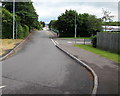
Into Penperlleni along School Lane
Viewed from the corner of the A4042 Usk Road looking past the Folly View Close junction towards the centre of Penperlleni. Goytre Fawr Primary School is ahead on the right.
Image: © Jaggery
Taken: 12 Jun 2016
0.02 miles
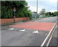
2
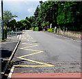
Zigzag yellow markings, School Lane, Penperlleni
Marking the keep clear zone near the main entrance to Goytre Fawr Primary School. https://www.geograph.org.uk/photo/6139897
Image: © Jaggery
Taken: 12 Jun 2016
0.02 miles
3
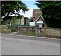
Goytre Fawr Community Centre, School Lane, Penperlleni
Housed in the old school building opposite the present-day school. https://www.geograph.org.uk/photo/6139897
The main user of the Community Centre is Goytre After School Club.
The Community Centre is available for hire outside the After School
Club times of 8am - 9am and 3pm - 6 pm (during term time).
Image: © Jaggery
Taken: 12 Jun 2016
0.02 miles
4
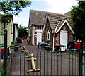
Old school buildings, School Lane, Penperlleni
Located opposite the present-day school https://www.geograph.org.uk/photo/6139897 the old school buildings house Goytre Fawr Community Centre.
Image: © Jaggery
Taken: 12 Jun 2016
0.02 miles
5
School Lane speed bump, Penperlleni
On the approach to Goytre Fawr Primary School.
Image: © Jaggery
Taken: 12 Jun 2016
0.03 miles
6
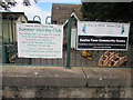
Goytre After School Club notices, School Lane, Penperlleni
On display in June 2016 on railings near the old school buildings https://www.geograph.org.uk/photo/6139918 which now house Goytre Fawr Community Centre.
Image: © Jaggery
Taken: 12 Jun 2016
0.03 miles
7
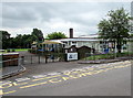
Main entrance to Goytre Fawr Primary School, Penperlleni
From School Lane.
Image: © Jaggery
Taken: 12 Jun 2016
0.03 miles
8
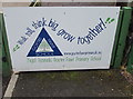
Walk tall, think big, grow together! School Lane, Penperlleni
At the main entrance https://www.geograph.org.uk/photo/6139897 to Goytre Fawr Primary School (Ysgol Gynradd Goytre Fawr in Welsh).
Image: © Jaggery
Taken: 12 Jun 2016
0.03 miles
9
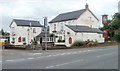
Goytre Arms, Penperlleni
Pub and restaurant at the western edge of the village, on the corner of the A4042 and Star Road.
Image: © Jaggery
Taken: 30 Jun 2011
0.03 miles
10
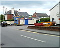
Goytre Fish Bar, Penperlleni
The village's takeaway is located on Star Road, next door to the Goytre Arms. http://www.geograph.org.uk/photo/2484987
You have the choice of fish and chips, or Indian curries, with tandoori style a speciality.
Image: © Jaggery
Taken: 30 Jun 2011
0.03 miles