IMAGES TAKEN NEAR TO
The Terrace, CALDICOT, NP26 5SS
Introduction
This page details the photographs taken nearby to The Terrace, NP26 5SS by members of the Geograph project.
The Geograph project started in 2005 with the aim of publishing, organising and preserving representative images for every square kilometre of Great Britain, Ireland and the Isle of Man.

There are currently over 7.5m images from over14,400 individuals and you can help contribute to the project by visiting https://www.geograph.org.uk
Image Map
Images are licensed for reuse under creativecommons.org/licenses/by-sa/2.0
Notes
- Clicking on the map will re-center to the selected point.
- The higher the marker number, the further away the image location is from the centre of the postcode.
Image Listing (51 Images Found)
Images are licensed for reuse under creativecommons.org/licenses/by-sa/2.0
Image
Details
Distance
1
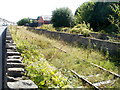
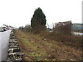
Overgrown railway line, Sudbrook
Viewed across the stone wall on the southern edge of Sudbrook Road.
Maps show that the disused track here follows almost exactly the course taken by the Severn Tunnel, metres below the surface, as it descends towards the River Severn.
Image: © Jaggery
Taken: 8 Sep 2010
0.04 miles
2
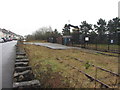
Sudbrook branch near the Network Rail pumping station
Looking east along the disused Sudbrook branch. The line was last used in the early 2000s, and is now disconnected from the main line.
Image: © Gareth James
Taken: 23 Mar 2013
0.04 miles
3
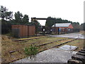
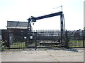
Network Rail's Sudbrook pumping station
In front is the disused Sudbrook branch. The line was last used in the early 2000s, and is now disconnected from the main line.
Image: © Gareth James
Taken: 23 Mar 2013
0.05 miles
4
The Terrace
The Severn Tunnel is somewhere under here in Sudbrook.
Image: © Burgess Von Thunen
Taken: 8 May 2012
0.05 miles
5
Pumping station close to the rails
Sudbrook is where the Severn tunnel takes the railway underground before its journey below the waves. Also on the line of the tracks is a pumping station.
Image: © Neil Owen
Taken: 20 Apr 2023
0.06 miles
6
Sudbrook branch
Looking east along the disused Sudbrook branch. The line was last used in the early 2000s, and is now disconnected from the main line.
Image: © Gareth James
Taken: 23 Mar 2013
0.06 miles
7
A glimpse of Sudbrook Paper Mill
Viewed from Sudbrook Road. The entrance http://www.geograph.org.uk/photo/2059260 to the mill is a few tens of metres away.
Image: © Jaggery
Taken: 8 Sep 2010
0.09 miles
8
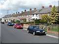
The Terrace, Sudbrook
The Terrace is a row of 18 houses on the north side of Sudbrook Road, at the western edge of the residential part of the village.
Image: © Jaggery
Taken: 8 Sep 2010
0.10 miles
9
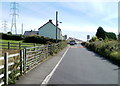
Western edge of residential Sudbrook
Sudbrook Road approaches houses at the western edge of the residential part of the village. Groups of houses along the road have different names. Those seen here are part of a row of 18 houses named The Terrace.
Image: © Jaggery
Taken: 8 Sep 2010
0.10 miles
10
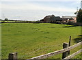
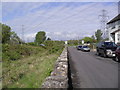
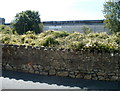
Southbrook Farm, Sudbrook
Viewed from Sudbrook Road.
Image: © Jaggery
Taken: 8 Sep 2010
0.10 miles