IMAGES TAKEN NEAR TO
Maes Siglen, NP26 4QZ
Introduction
This page details the photographs taken nearby to Maes Siglen, NP26 4QZ by members of the Geograph project.
The Geograph project started in 2005 with the aim of publishing, organising and preserving representative images for every square kilometre of Great Britain, Ireland and the Isle of Man.

There are currently over 7.5m images from over14,400 individuals and you can help contribute to the project by visiting https://www.geograph.org.uk
Image Map
Images are licensed for reuse under creativecommons.org/licenses/by-sa/2.0
Notes
- Clicking on the map will re-center to the selected point.
- The higher the marker number, the further away the image location is from the centre of the postcode.
Image Listing (5 Images Found)
Images are licensed for reuse under creativecommons.org/licenses/by-sa/2.0
Image
Details
Distance
1
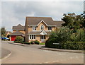
Corner of Heol Glaslyn and Church Road, Caldicot
Viewed from Church Road.
Image: © Jaggery
Taken: 14 Aug 2010
0.15 miles
2
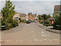
Heol Glaslyn, Caldicot
Viewed from Church Road.
Image: © Jaggery
Taken: 14 Aug 2010
0.15 miles
3
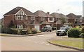
Clos Rheidol, Caldicot
Viewed from Church Road.
Image: © Jaggery
Taken: 14 Aug 2010
0.19 miles
4
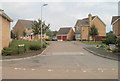
Heol Towy, Caldicot
Viewed from Church Road.
Image: © Jaggery
Taken: 14 Aug 2010
0.22 miles
5
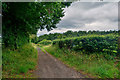
Caldicot : Track
A track heading through the countryside.
Image: © Lewis Clarke
Taken: 15 Jul 2020
0.25 miles