IMAGES TAKEN NEAR TO
Windsor Park, CALDICOT, NP26 3NJ
Introduction
This page details the photographs taken nearby to Windsor Park, NP26 3NJ by members of the Geograph project.
The Geograph project started in 2005 with the aim of publishing, organising and preserving representative images for every square kilometre of Great Britain, Ireland and the Isle of Man.

There are currently over 7.5m images from over14,400 individuals and you can help contribute to the project by visiting https://www.geograph.org.uk
Image Map
Images are licensed for reuse under creativecommons.org/licenses/by-sa/2.0
Notes
- Clicking on the map will re-center to the selected point.
- The higher the marker number, the further away the image location is from the centre of the postcode.
Image Listing (234 Images Found)
Images are licensed for reuse under creativecommons.org/licenses/by-sa/2.0
Image
Details
Distance
1
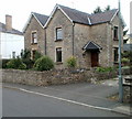
Myrtle Cottage, West End, Magor
Located near the Redwick Road side of West End.
The cottage dates from 1850, the year in which the South Wales Railway from Chepstow to Swansea opened. Though Magor railway station closed in 1964, the railway lines continue in use, part of the South Wales main line which runs near the cottage.
Image: © Jaggery
Taken: 14 Aug 2010
0.09 miles
2
Withy Close, Magor
Viewed from the corner of Withy Drive.
Image: © Jaggery
Taken: 4 Feb 2018
0.10 miles
3
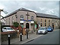
Ebenezer Baptist Church, Magor
Located in The Square. Grade II listed building, dating from 1816.
Image: © Jaggery
Taken: 14 Aug 2010
0.10 miles
4
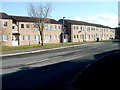
Withy Walk, Magor
Houses on the NE side of Withy Walk viewed from the corner of Redwick Road.
Image: © Jaggery
Taken: 11 Feb 2011
0.10 miles
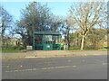
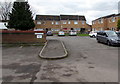
6
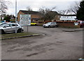
Withy Close Car Park, Magor
Free car park for cars and light vans viewed from the corner of Withy Walk.
Image: © Jaggery
Taken: 4 Feb 2018
0.12 miles
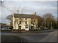
8
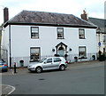
Magor House, The Square, Magor
Grade II listing building located on the west side of The Square, next door to The Golden Lion. http://www.geograph.org.uk/photo/2027918
The house dates from the late eighteenth or early nineteenth century. The forecourt has wrought iron railings and gate.
Image: © Jaggery
Taken: 14 Aug 2010
0.12 miles
9
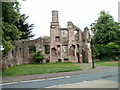
Remains of the Procurator's House, Magor
Located on the east side of Redwick Road, on the western edge of St Mary's church grounds. The following text appears on a plaque on the building :
The Procurator's House
800 years ago the Procurator lived here.
His duties were to preside over a court in which rates of pay, boundary and other disputes were settled and to collect rents and other local taxes which he then transferred to the Catholic Church in Italy.
A man of some standing he was normally a priest well versed in the law and enjoyed considerable wealth, similar in status to a steward of a manor or great estate.
The impressive size and solidarity of these remains, dating from the 14th century, reflect his status.
This building is the only one of its kind in Wales.
Magor Community Council.
Image: © Jaggery
Taken: 14 Aug 2010
0.12 miles
10
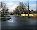
Tree-lined Redwick Road, Magor, Monmouthshire
Viewed across Newport Road in December 2020.
Image: © Jaggery
Taken: 15 Dec 2020
0.13 miles