IMAGES TAKEN NEAR TO
Dancing Close, CALDICOT, NP26 3JT
Introduction
This page details the photographs taken nearby to Dancing Close, NP26 3JT by members of the Geograph project.
The Geograph project started in 2005 with the aim of publishing, organising and preserving representative images for every square kilometre of Great Britain, Ireland and the Isle of Man.

There are currently over 7.5m images from over14,400 individuals and you can help contribute to the project by visiting https://www.geograph.org.uk
Image Map
Images are licensed for reuse under creativecommons.org/licenses/by-sa/2.0
Notes
- Clicking on the map will re-center to the selected point.
- The higher the marker number, the further away the image location is from the centre of the postcode.
Image Listing (51 Images Found)
Images are licensed for reuse under creativecommons.org/licenses/by-sa/2.0
Image
Details
Distance
1

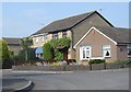
Dancing Close in Undy
Dancing Close is a cul-de-sac on the north side of Quarry Rise. Dancing Hill is nearby.
An Undy resident told me that Dancing is derived from a local family name, Daunsing or similar whereas an online source states that, according to legend, fairies are to be seen dancing on the hill on Midsummer eve. Hmm....
Image: © Jaggery
Taken: 11 Feb 2018
0.01 miles
2
Come Dancing...?
This little road, part of a housing estate in Magor goes under the delightful name of "Dancing Close". How could I resist posting it on Geograph?
Image: © Ruth Sharville
Taken: 30 Apr 2007
0.03 miles
3

Hawthorn Close, Undy
Cul-de-sac on the north side of Quarry Rise.
Image: © Jaggery
Taken: 11 Feb 2018
0.04 miles
4
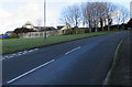
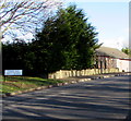
Quarry Rise, Undy
Quarry Rise ascends from the Grange Road junction https://www.geograph.org.uk/photo/5680853 towards the Dancing Close junction. https://www.geograph.org.uk/photo/5676770
Image: © Jaggery
Taken: 11 Feb 2018
0.04 miles
5
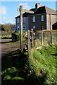
Footpath signpost, Grange Road, Undy
The signpost is at the edge of this stile. https://www.geograph.org.uk/photo/5680906
Image: © Jaggery
Taken: 11 Feb 2018
0.05 miles
6
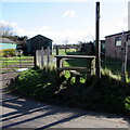
Grange Road stile to a footpath, Undy
The footpath is on the east side of Grange Road at the northern edge of Undy.
Image: © Jaggery
Taken: 11 Feb 2018
0.05 miles
7
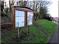
Magor with Undy Community Council noticeboard, Undy
Alongside Quarry Rise in Undy. A woodland path https://www.geograph.org.uk/photo/5676819 is on the right.
Image: © Jaggery
Taken: 11 Feb 2018
0.05 miles
8
Quarry Rise name sign, Undy
The sign near the Dancing Hill junction shows that Quarry Rise is Rhiw'r Chwarel in Welsh.
Image: © Jaggery
Taken: 11 Feb 2018
0.05 miles
9
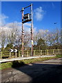
Western Power Distribution line spur pole, Grange Road, Undy
A rural part of the electricity infrastructure above the south side of the M4 motorway.
Image: © Jaggery
Taken: 11 Feb 2018
0.07 miles
10
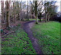
Path into woodland, Undy
From the south side of Quarry Rise.
Image: © Jaggery
Taken: 11 Feb 2018
0.07 miles