IMAGES TAKEN NEAR TO
Seymour Way, CALDICOT, NP26 3GF
Introduction
This page details the photographs taken nearby to Seymour Way, NP26 3GF by members of the Geograph project.
The Geograph project started in 2005 with the aim of publishing, organising and preserving representative images for every square kilometre of Great Britain, Ireland and the Isle of Man.

There are currently over 7.5m images from over14,400 individuals and you can help contribute to the project by visiting https://www.geograph.org.uk
Image Map
Images are licensed for reuse under creativecommons.org/licenses/by-sa/2.0
Notes
- Clicking on the map will re-center to the selected point.
- The higher the marker number, the further away the image location is from the centre of the postcode.
Image Listing (10 Images Found)
Images are licensed for reuse under creativecommons.org/licenses/by-sa/2.0
Image
Details
Distance
1
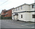
Head Office and Training Unit, Community Care Enterprises Limited, Magor
Located at the western end of West End, Magor, alongside the South Wales main railway line.
Image: © Jaggery
Taken: 14 Aug 2010
0.10 miles
2
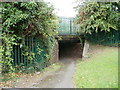
Magor Crossing underpass
Unusually for an underpass, this one beneath the South Wales main railway line is named on maps - Magor Crossing. Viewed from the north side of the tracks, at the far western end of West End.
On the other side of the tracks is Blue House Farm and Barecroft Common.
Image: © Jaggery
Taken: 14 Aug 2010
0.10 miles
3
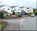
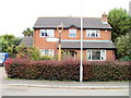
Houses on the corner of Blenheim Avenue and Blenheim Close, Magor
Viewed across Blenheim Avenue.
Image: © Jaggery
Taken: 14 Aug 2010
0.12 miles
4
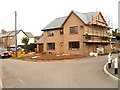
New house nearing completion, West End, Magor
External work is nearing completion on a house being built on the corner of West End and Green Moor Lane, Magor.
Image: © Jaggery
Taken: 14 Aug 2010
0.15 miles
5
Old-style signpost, West End, Magor
At the T-junction of West End and Green Moor Lane, embedded in a hedge, a rusting and flaking signpost points to the east along West End. Just about legible is 'Magor'.
The volume of traffic from Green Moor Lane was very low during my visit, so perhaps the council decided it was not worth the expense of erecting a new-style signpost here.
Image: © Jaggery
Taken: 14 Aug 2010
0.15 miles
6
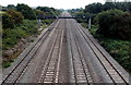
Signal gantry near Magor
Looking east along the South Wales main railway line from a road bridge near Llandevenny.
Image: © Jaggery
Taken: 3 Sep 2013
0.18 miles
7
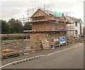
House construction, West End, Magor
Scaffolding surrounds a house being built on the south side of West End. The South Wales main railway line is in the background on the left.
Image: © Jaggery
Taken: 14 Aug 2010
0.20 miles
8
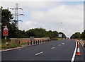
A4810 bridge over the South Wales main line near Magor
The bridge carries the A4810 over a 4-track railway line. http://www.geograph.org.uk/photo/3741045
Image: © Jaggery
Taken: 3 Sep 2013
0.24 miles
9
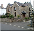
Myrtle Cottage, West End, Magor
Located near the Redwick Road side of West End.
The cottage dates from 1850, the year in which the South Wales Railway from Chepstow to Swansea opened. Though Magor railway station closed in 1964, the railway lines continue in use, part of the South Wales main line which runs near the cottage.
Image: © Jaggery
Taken: 14 Aug 2010
0.24 miles
10
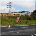
Kegs and a pylon near Magor
Hundreds of kegs are stacked in the SE corner of a brewery.
Image: © Jaggery
Taken: 3 Sep 2013
0.24 miles