IMAGES TAKEN NEAR TO
Rockfield View, CALDICOT, NP26 3FJ
Introduction
This page details the photographs taken nearby to Rockfield View, NP26 3FJ by members of the Geograph project.
The Geograph project started in 2005 with the aim of publishing, organising and preserving representative images for every square kilometre of Great Britain, Ireland and the Isle of Man.

There are currently over 7.5m images from over14,400 individuals and you can help contribute to the project by visiting https://www.geograph.org.uk
Image Map
Images are licensed for reuse under creativecommons.org/licenses/by-sa/2.0
Notes
- Clicking on the map will re-center to the selected point.
- The higher the marker number, the further away the image location is from the centre of the postcode.
Image Listing (14 Images Found)
Images are licensed for reuse under creativecommons.org/licenses/by-sa/2.0
Image
Details
Distance
1
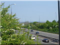
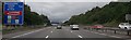
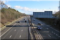
M 4 Motorway near Magor
The photo was taken from the road bridge just south of Knollbury. The motorway here is about to divide into the M4 and the M48, leading respectively to the Second Severn Crossing, and the Severn Bridge. You can just make out the causeway leading to the Second Severn Crossing, and the distinctive bridge structure, which, like the first bridge, can be seen for miles around in this area.
Image: © Ruth Sharville
Taken: 30 Apr 2007
0.18 miles
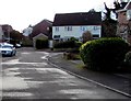
3

Rowan Close, Undy
Cul-de-sac on the northeast side of Quarry Rise.
Image: © Jaggery
Taken: 11 Feb 2018
0.20 miles
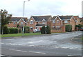
4
St Stephens Court, Undy
Houses on St Stephens Court viewed from Elms Hill, the local name for this part of the B4245.
Image: © Jaggery
Taken: 14 Aug 2010
0.21 miles
5
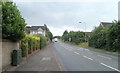
Elms Hill, Undy
The main road through the village of Undy, the B4245, is here named Elms Hill.
Image: © Jaggery
Taken: 14 Aug 2010
0.21 miles
7
Quarry Rise, Undy
Looking towards the turning area at the eastern end of Quarry Rise.
Image: © Jaggery
Taken: 11 Feb 2018
0.21 miles
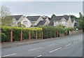
8
Rockfield Grove, Undy
Modern houses near the eastern edge of the village, viewed from the B4245.
Image: © Jaggery
Taken: 14 Aug 2010
0.21 miles
9
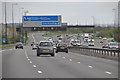
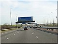
Monmouthshire : M4 Motorway
The M4 Motorway heading eastbound as it passes through Monmouthshire.
Image: © Lewis Clarke
Taken: 11 Apr 2014
0.22 miles
10
East along the M4 motorway near Knollbury, Monmouthshire
Viewed from this https://www.geograph.org.uk/photo/5680937 bridge.
Image: © Jaggery
Taken: 11 Feb 2018
0.23 miles