IMAGES TAKEN NEAR TO
Llanvaches, CALDICOT, NP26 3BE
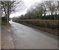
Introduction
This page details the photographs taken nearby to NP26 3BE by members of the Geograph project.
The Geograph project started in 2005 with the aim of publishing, organising and preserving representative images for every square kilometre of Great Britain, Ireland and the Isle of Man.

There are currently over 7.5m images from over14,400 individuals and you can help contribute to the project by visiting https://www.geograph.org.uk
Image Map
Images are licensed for reuse under creativecommons.org/licenses/by-sa/2.0
Notes
- Clicking on the map will re-center to the selected point.
- The higher the marker number, the further away the image location is from the centre of the postcode.
Image Listing (72 Images Found)
Images are licensed for reuse under creativecommons.org/licenses/by-sa/2.0
Image
Details
Distance
1
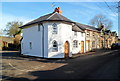
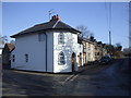
Old Turnpike Cottages south of Llanvaches
Viewed along Pike Road at a Y-shaped junction. Pike Road behind the camera continues on the right, so it appears that a toll had to be paid to use that road, whereas the road to Llanvaches on the left was free to use. Tolls on turnpike roads were abolished in the UK in 1872, after which the roads were maintained by local authorities.
Image: © Jaggery
Taken: 16 Feb 2012
0.01 miles
2
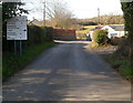
Pike Road approaches a junction south of Llanvaches
Viewed along a former turnpike road.
Image: © Jaggery
Taken: 16 Feb 2012
0.01 miles
3
Old Turnpike Cottages south of Llanvaches
Viewed along Pike Road.
Image: © Jaggery
Taken: 16 Feb 2012
0.01 miles
4
? mile to Llanvaches
The road from Penhow to Llanvaches passes Old Turnpike Cottages. http://www.geograph.org.uk/photo/3782406
Image: © Jaggery
Taken: 16 Feb 2012
0.01 miles
5
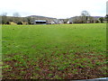
Farm buildings east of Penhow
Looking towards Pike Road from the A48.
Image: © Jaggery
Taken: 15 Feb 2012
0.03 miles
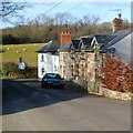
6
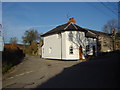
Cottages
Old cottages at fork on Pike Road. OS map describes them as Old Turnpike Cottages
Image: © John Whiteside
Taken: 23 Jan 2007
0.04 miles
8
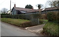
Rock View near Llanvaches
Viewed from Pike Road about 250 metres NE of the A48.
Image: © Jaggery
Taken: 16 Feb 2012
0.05 miles
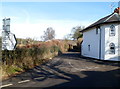
9
Pike Road, Llanvaches
Looking to the northeast along Pike Road towards Old Turnpike Cottages. https://www.geograph.org.uk/photo/3782406
Image: © Jaggery
Taken: 15 Jan 2019
0.05 miles
10
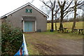
The Pike Den and picnic tables near Llanvaches
About 100 metres north of Pike Road and Old Turnpike Cottages, The Pike Den is the home of
1st Wentwood Scout Group, first registered in March 1971. This building was officially opened in April 1985.
Image: © Jaggery
Taken: 16 Feb 2012
0.06 miles