IMAGES TAKEN NEAR TO
Magor, CALDICOT, NP26 3AL
Introduction
This page details the photographs taken nearby to NP26 3AL by members of the Geograph project.
The Geograph project started in 2005 with the aim of publishing, organising and preserving representative images for every square kilometre of Great Britain, Ireland and the Isle of Man.

There are currently over 7.5m images from over14,400 individuals and you can help contribute to the project by visiting https://www.geograph.org.uk
Image Map
Images are licensed for reuse under creativecommons.org/licenses/by-sa/2.0
Notes
- Clicking on the map will re-center to the selected point.
- The higher the marker number, the further away the image location is from the centre of the postcode.
Image Listing (7 Images Found)
Images are licensed for reuse under creativecommons.org/licenses/by-sa/2.0
Image
Details
Distance
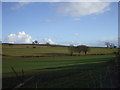
1
Field edge footpath
Also a bridleway I believe.
Image: © Jeremy Bolwell
Taken: 21 Oct 2012
0.14 miles
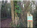
4
Entrance to Penhow Woodlands Nature Reserve
Image: © John Lord
Taken: 5 Feb 2010
0.17 miles
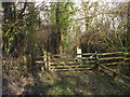
6
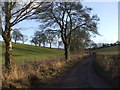
Bowdens Lane
A blue Motorway sign on the M4 can just be seen in the centre of the photo
Image: © John Lord
Taken: 5 Feb 2010
0.21 miles
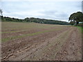
7
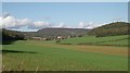
View towards Penhow Castle
Landscape immediately north of the Gwent levels at Magor is characterised by shallow valleys cut into low hills of Carboniferous limestone and limestone shales. Steeper slopes and hill tops are often wooded. The winter cereal crop is beginning to show.
Image: © Gill Stott
Taken: 26 Oct 2006
0.22 miles