IMAGES TAKEN NEAR TO
Parc Seymour, Penhow, CALDICOT, NP26 3AB
Introduction
This page details the photographs taken nearby to NP26 3AB by members of the Geograph project.
The Geograph project started in 2005 with the aim of publishing, organising and preserving representative images for every square kilometre of Great Britain, Ireland and the Isle of Man.

There are currently over 7.5m images from over14,400 individuals and you can help contribute to the project by visiting https://www.geograph.org.uk
Image Map
Images are licensed for reuse under creativecommons.org/licenses/by-sa/2.0
Notes
- Clicking on the map will re-center to the selected point.
- The higher the marker number, the further away the image location is from the centre of the postcode.
Image Listing (20 Images Found)
Images are licensed for reuse under creativecommons.org/licenses/by-sa/2.0
Image
Details
Distance
1
Penhow Village Shop
Situated in the centre of the dormitory village of Parc-Seymour a few miles east of Newport.
Image: © Jonathan Billinger
Taken: 11 Jul 2018
0.01 miles
2
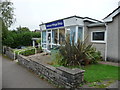
Penhow Village Shop, Parc Seymour
It used to be the local Post Office and is now run, seemingly, by the village and staffed by volunteers. It's a great store - very reasonable prices (apples at 10p) and including features like 'free pears' donated by locals who have surplus produce and who don't wish necessarily to profit from their sale, just donate to the greater good. The pear was delicious by the way. The service was bright, cheery and efficient and many a so-called convenience store could learn a few lessons from this retail operation.
Image: © Jeremy Bolwell
Taken: 21 Sep 2013
0.01 miles
3
Penhow Village Shop, Parc Seymour
Located at 1 Greenmeadow Drive, Parc Seymour, the shop sells groceries, newspapers and frozen food, and a range of organic and fairtrade foods.
When in 2008 it was announced that the post office inside the shop would close, local residents banded together to ensure that the shop remained open. More than 100 residents each gave a minimum £50 unsecured loan towards the running and refurbishment of the village shop, with no certainly that the project would be completed. The new shop was formally opened on November 4th 2008, staffed by a rota of 50 volunteers, who do an average of two hours each week in shifts of two.
Image: © Jaggery
Taken: 28 Jan 2011
0.02 miles
4
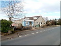
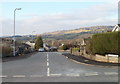
Parc-Seymour
A dormitory for Newport just north of the A48.
Image: © Jonathan Billinger
Taken: 11 Jul 2018
0.06 miles
5
NE edge of Greenmeadow Drive, Parc Seymour
The view west along Greenmeadow Drive. A few metres away on the right is the turning for Greenmeadow Close.
Image: © Jaggery
Taken: 28 Jan 2011
0.08 miles
6
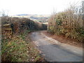
Duckpool Lane near Parc Seymour
Duckpool Lane curves away from a junction http://www.geograph.org.uk/photo/2248800 with two other lanes, heading towards Duckpool Farm.
Image: © Jaggery
Taken: 28 Jan 2011
0.10 miles
7
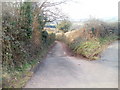
Lane from the north of Parc Seymour to the A48
A lane heads away from a junction http://www.geograph.org.uk/photo/2248800 with two other lanes, along the western edge of the village of Parc Seymour, towards the A48.
Image: © Jaggery
Taken: 28 Jan 2011
0.10 miles
8
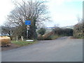
Junction of three lanes north of Parc Seymour
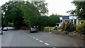
Three lanes meet ahead, a short distance north of Parc Seymour. The white-on-blue sign stating 'Unsuitable for heavy goods vehicles' appears to relate to the leftmost lane, but perhaps it applies to all three, which are all narrow.
The lane on the left heads SSW along the western edge of Parc Seymour, towards the A48.
The centre lane, named Duckpool Lane, heads for Duckpool Farm.
The lane on the right heads into Wentwood, with a side lane to two farms.
Image: © Jaggery
Taken: 28 Jan 2011
0.10 miles
9
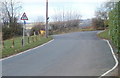
Northern edge of Parc Seymour
At the northern edge of the village of Parc Seymour, signs advise of the narrowing of the road ahead, and the start of the national speed limit.
Image: © Jaggery
Taken: 28 Jan 2011
0.10 miles
10
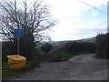
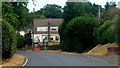
Country lane junction at Parc-Seymour
Note the strategically-placed salt bucket...
Image: © Ruth Sharville
Taken: 10 Mar 2007
0.10 miles