1
Houses west of Portal Road, Monmouth
Most of the houses are in Castle Close, except for the far left (St Crispin Close).
Image: © Jaggery
Taken: 26 Oct 2014
0.07 miles
2
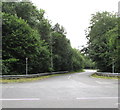
Tree-lined Link Road, Monmouth
From the west side of Portal Road, Link Road leads to Wonastow Road Industrial Estate.
Image: © Jaggery
Taken: 7 Jul 2020
0.08 miles
3
Link Road, Monmouth
Viewed across Portal Road. Link Road skirts the edge of the Over Monnow district of Monmouth.
Image: © Jaggery
Taken: 24 Apr 2011
0.08 miles
4
Path towards Castle Close in Monmouth
From Portal Road.
Image: © Jaggery
Taken: 26 Oct 2014
0.08 miles
5
Cycling out of Monmouth
Leaving the 30mph zone, three cyclists in Portal Road enter the National Speed Limit zone.
Image: © Jaggery
Taken: 26 Oct 2014
0.09 miles
6
From 40 to 30 on Portal Road, Overmonnow, Monmouth
The 40mph speed limit on the B4293 Portal Road drops to 30mph on the approach to Monmouth town centre.
Image: © Jaggery
Taken: 7 Jul 2020
0.09 miles
7
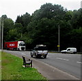
Connolly's RED MILLS lorry in Overmonnow, Monmouth
The 6-axle articulated lorry travelling north on Portal Road enters the 30mph speed limit zone on the approach to Monmouth town centre on July 7th 2020. Text on the lorry includes "SINCE 1908". The business supplies feed for horses and other animals. Its website states that since Michael Connolly bought the famous mill in Goresbridge, County Kilkenny, Connolly’s RED MILLS has grown from a local mill in southeast Ireland to a global brand, available in 73 countries around the world.
Image: © Jaggery
Taken: 7 Jul 2020
0.09 miles
8
Roadside bench in Overmonnow, Monmouth
Alongside Portal Road near the Link Road junction on the right.
Image: © Jaggery
Taken: 7 Jul 2020
0.10 miles
9
The Albion, Monmouth
The Albion is a rectangular area on the corner of Cinderhill Street (B4293) and Goldwire Lane.
In view are the corner premises, Albion Cafe & Shop and behind it, Albion Fish & Chips.
Image: © Jaggery
Taken: 13 Jan 2011
0.10 miles
10
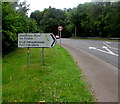
Bilingual direction sign, Portal Road, Overmonnow, Monmouth
Turn right ahead into Link Road https://www.geograph.org.uk/photo/6529535 for Wonastow Road Industrial Estate.
The sign shows that Wonastow is Llanwarw in Welsh.
Image: © Jaggery
Taken: 7 Jul 2020
0.10 miles


