IMAGES TAKEN NEAR TO
St. Thomas Road, MONMOUTH, NP25 5SB
Introduction
This page details the photographs taken nearby to St. Thomas Road, NP25 5SB by members of the Geograph project.
The Geograph project started in 2005 with the aim of publishing, organising and preserving representative images for every square kilometre of Great Britain, Ireland and the Isle of Man.

There are currently over 7.5m images from over14,400 individuals and you can help contribute to the project by visiting https://www.geograph.org.uk
Image Map
Images are licensed for reuse under creativecommons.org/licenses/by-sa/2.0
Notes
- Clicking on the map will re-center to the selected point.
- The higher the marker number, the further away the image location is from the centre of the postcode.
Image Listing (117 Images Found)
Images are licensed for reuse under creativecommons.org/licenses/by-sa/2.0
Image
Details
Distance
1
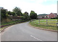
Watery Lane, Monmouth
Looking to the WSW along Watery Lane from near the Chartist Rise junction.
Image: © Jaggery
Taken: 18 Aug 2020
0.11 miles
2
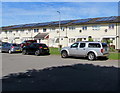
Rooftop solar panels, Kings Fee, Monmouth
In the Overmonnow area of Monmouth.
Image: © Jaggery
Taken: 12 Jul 2020
0.12 miles
3
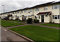
Solar panels, Kings Fee, Monmouth
In late October 2014, most of the roofs have solar panels.
There were none here in a Google Earth Street View taken in September 2009.
Image: © Jaggery
Taken: 26 Oct 2014
0.13 miles
4
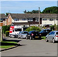
Iceland home delivery van, Kings Fee, Monmouth
Red and white van parked in the Overmonnow area of Monmouth in July 2020.
Image: © Jaggery
Taken: 12 Jul 2020
0.13 miles
5
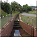
Stepped water channel in Monmouth
Below Watery Lane on the right.
Image: © Jaggery
Taken: 18 Aug 2020
0.13 miles
6
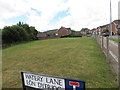
Field on a Monmouth corner
On the corner of Chartist Rise and Watery Lane (Lôn Dyfriog in Welsh).
Image: © Jaggery
Taken: 18 Aug 2020
0.13 miles
7
Wonastow Road Industrial Estate, Monmouth
Another builders' merchant, within a short stone's throw of Image
Image: © Jonathan Billinger
Taken: 24 Oct 2008
0.13 miles
8
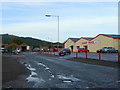
Chartist Rise, Monmouth
This part of Chartist Rise is between the Cornpoppy Avenue junction
near the camera and the Cornwallis Way junction out of shot ahead.
Image: © Jaggery
Taken: 18 Aug 2020
0.13 miles
9
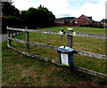
Drop it - Bag it - Bin it, Watery Lane, Monmouth
A hand sanitiser is on the fence above the litter bin.
Image: © Jaggery
Taken: 18 Aug 2020
0.14 miles
10
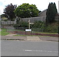
Offa's Dyke Path signpost, Watery Lane, Monmouth
https://www.geograph.org.uk/photo/6573493 to a closer view.
Offa's Dyke Path is a long-distance footpath broadly following the Wales/England border.
It extends from Chepstow in the south of South Wales to Prestatyn in the north of North Wales.
Image: © Jaggery
Taken: 18 Aug 2020
0.14 miles