IMAGES TAKEN NEAR TO
Manson, MONMOUTH, NP25 5RA
Introduction
This page details the photographs taken nearby to NP25 5RA by members of the Geograph project.
The Geograph project started in 2005 with the aim of publishing, organising and preserving representative images for every square kilometre of Great Britain, Ireland and the Isle of Man.

There are currently over 7.5m images from over14,400 individuals and you can help contribute to the project by visiting https://www.geograph.org.uk
Image Map
Images are licensed for reuse under creativecommons.org/licenses/by-sa/2.0
Notes
- Clicking on the map will re-center to the selected point.
- The higher the marker number, the further away the image location is from the centre of the postcode.
Image Listing (65 Images Found)
Images are licensed for reuse under creativecommons.org/licenses/by-sa/2.0
Image
Details
Distance
1
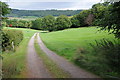
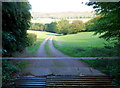
Track to Cannes Farm
Track to Cannes Farm across a golf course on the edge of Monmouth.
Image: © Philip Halling
Taken: 21 Sep 2013
0.06 miles
2
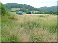
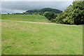
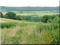
Grazing land east of Hereford Road, Monmouth
Buckholt Wood and Pyefinch Wood in the distance.
Not sure whether the truck is abandoned here, but on the stile entering this field was a notice gathering opposition to development of housing on this land.
Image: © Jonathan Billinger
Taken: 14 Jul 2009
0.06 miles
3
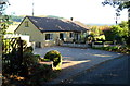
Brywen SE of Hereford Road, Monmouth
The bungalow is on Manson's Lane, the northward continuation of Leasbrook Lane on the route from Dixton (to the south) to Hereford Road.
Image: © Jaggery
Taken: 22 Oct 2011
0.06 miles
4
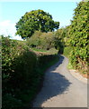
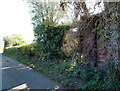
Narrow lane to Hereford Road, Monmouth
Viewed from opposite a cattle grid, http://www.geograph.org.uk/photo/2662273 the hedged Manson's Lane climbs towards Hereford Road.
Image: © Jaggery
Taken: 22 Oct 2011
0.06 miles
5
Cattle grid across track to Cannes Farm, Monmouth
Viewed from Leasbrook Lane. The track crosses Monmouth Golf Club's course.
Image: © Jaggery
Taken: 22 Oct 2011
0.07 miles
6
Farmland near Dixton
Farmland near Dixton to the north of Monmouth.
Image: © Philip Halling
Taken: 21 Sep 2013
0.07 miles
7
Whitewall tyres, Monmouth Golf Course
Viewed from the edge of a depot. http://www.geograph.org.uk/photo/2662318
I do not know the golfing use for the tyres. Possibly targets to aim at during golf practice? I doubt that golfers hurl themselves through the tyres, commando-style, during fitness training !
Image: © Jaggery
Taken: 22 Oct 2011
0.09 miles
8
Remains of a railway wagon shed, Manson's Lane, Monmouth
Partly hidden by vegetation, the brown edge of a former railway wagon can be seen on the right side.
It appears to be long abandoned. Part of the wooden roof has disappeared, and it is in a dilapidated condition. The back of the shed is absent. A barbed wire fence prevents access to the field behind it.
Image: © Jaggery
Taken: 22 Oct 2011
0.09 miles
9
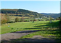
View north-east from Monmouth
Looking along the line of the public path to Cannes Farm.
Joint Wood, and the English border runs along the ridge beyond.
Image: © Jonathan Billinger
Taken: 14 Jul 2009
0.12 miles
10
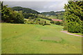
Golf course near Monmouth
Golf course beside Manson's Lane just to the north of Monmouth.
Image: © Philip Halling
Taken: 21 Sep 2013
0.14 miles