IMAGES TAKEN NEAR TO
St. Maughans, MONMOUTH, NP25 5QQ
Introduction
This page details the photographs taken nearby to NP25 5QQ by members of the Geograph project.
The Geograph project started in 2005 with the aim of publishing, organising and preserving representative images for every square kilometre of Great Britain, Ireland and the Isle of Man.

There are currently over 7.5m images from over14,400 individuals and you can help contribute to the project by visiting https://www.geograph.org.uk
Image Map
Images are licensed for reuse under creativecommons.org/licenses/by-sa/2.0
Notes
- Clicking on the map will re-center to the selected point.
- The higher the marker number, the further away the image location is from the centre of the postcode.
Image Listing (4 Images Found)
Images are licensed for reuse under creativecommons.org/licenses/by-sa/2.0
Image
Details
Distance
1
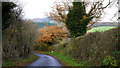
Lane in the Monnow valley
This IS 'the beaten track' around here.
The oak is in final bronze colour for 2013.
Image: © Jonathan Billinger
Taken: 9 Dec 2013
0.10 miles
2
Drive to Blackmoor Farm
A footpath follows the farm road down to the Monnow valley floor.
See same scene taken over seven years earlier - Image
Image: © Jonathan Billinger
Taken: 9 Dec 2013
0.12 miles
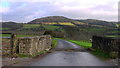
3

Farm road to Blackmoor Farm
Entrance and farm road to Blackmoor Farm.
Image: © Philip Halling
Taken: 23 Sep 2006
0.12 miles
4
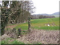
Footpath and field edge
This way leads to Blackmore Farm and the Monnow valley.
Image: © Jonathan Billinger
Taken: 12 Mar 2007
0.13 miles