IMAGES TAKEN NEAR TO
The Hendre, MONMOUTH, NP25 5NX
Introduction
This page details the photographs taken nearby to NP25 5NX by members of the Geograph project.
The Geograph project started in 2005 with the aim of publishing, organising and preserving representative images for every square kilometre of Great Britain, Ireland and the Isle of Man.

There are currently over 7.5m images from over14,400 individuals and you can help contribute to the project by visiting https://www.geograph.org.uk
Image Map
Images are licensed for reuse under creativecommons.org/licenses/by-sa/2.0
Notes
- Clicking on the map will re-center to the selected point.
- The higher the marker number, the further away the image location is from the centre of the postcode.
Image Listing (5 Images Found)
Images are licensed for reuse under creativecommons.org/licenses/by-sa/2.0
Image
Details
Distance
1
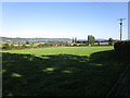
The Grange, Llangattock-Vibon-Avel
Image: © Jonathan Thacker
Taken: 18 Sep 2019
0.03 miles
3
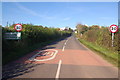
No sign of the Toon Army here! Newcastle, Monmouthshire
Image: © Roger Davies
Taken: 17 Oct 2008
0.21 miles
4
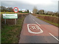
SE boundary of Newcastle Monmouthshire
The B4347 from Rockfield reaches the NE Monmouthshire hamlet of Newcastle.
Image: © Jaggery
Taken: 22 Jan 2012
0.25 miles
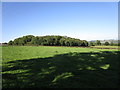
5
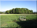
Grass field and Pointers Wood
Most of the wood is in the next square.
Image: © Jonathan Thacker
Taken: 18 Sep 2019
0.25 miles