IMAGES TAKEN NEAR TO
Mansons Cross, MONMOUTH, NP25 5LE
Introduction
This page details the photographs taken nearby to NP25 5LE by members of the Geograph project.
The Geograph project started in 2005 with the aim of publishing, organising and preserving representative images for every square kilometre of Great Britain, Ireland and the Isle of Man.

There are currently over 7.5m images from over14,400 individuals and you can help contribute to the project by visiting https://www.geograph.org.uk
Image Map
Images are licensed for reuse under creativecommons.org/licenses/by-sa/2.0
Notes
- Clicking on the map will re-center to the selected point.
- The higher the marker number, the further away the image location is from the centre of the postcode.
Image Listing (49 Images Found)
Images are licensed for reuse under creativecommons.org/licenses/by-sa/2.0
Image
Details
Distance
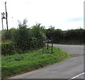
1
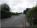
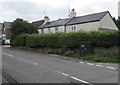
Hereford Road from Manson's Cross towards the centre of Monmouth
Looking south along the A466 Hereford Road at the northern edge of Monmouth.
A small dark green telecoms cabinet http://www.geograph.org.uk/photo/5084419 is on the right.
Image: © Jaggery
Taken: 21 Aug 2016
0.01 miles
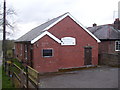
3
Buckholt Village Hall
On the corner of Withy Lane and Hereford Road, built in 1929 by public subscription.
http://www.geograph.org.uk/photo/2662459 to an earlier view and some details.
Image: © Jaggery
Taken: 21 Aug 2016
0.01 miles
4
Buckholt Village Hall
Buckholt Village Hall beside the A466 to the north of Monmouth.
Image: © Philip Halling
Taken: 21 Sep 2013
0.02 miles
5
Cannes Farm direction sign, Monmouth
Facing Hereford Road. The white arrow on the sign points left to Manson Lane http://www.geograph.org.uk/photo/5084181 towards Dixton.
Image: © Jaggery
Taken: 21 Aug 2016
0.02 miles
6
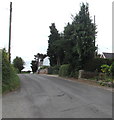
South along Hereford Road, Monmouth
The A466 Hereford towards the centre of Monmouth, about 2km ahead.
Image: © Jaggery
Taken: 21 Aug 2016
0.02 miles
7
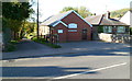
Buckholt Village Hall
Located south of the Buckholt boundary, in Manson's Cross, on the corner of the A466 and Withy Lane. The hall, built in 1929 by public subscription, is the centre of Buckholt activities. Among the many activities and clubs using the hall are the annual flower show, fete, Dramatic Society, Village Produce Association, youth club, the weekly Olde Tyme Dance Club, the Women's Institute, the Mothers' Union, mother & toddler group and table tennis club.
The hall committee arranges events such as musical evenings and coffee evenings to help maintain the hall for future generations.
Image: © Jaggery
Taken: 22 Oct 2011
0.04 miles
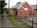
8
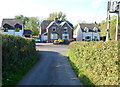
Hereford Road houses facing Manson Lane, Monmouth
Manson Lane is the northern continuation of Leasbrook Lane, a narrow country road from Dixton.
Image: © Jaggery
Taken: 22 Oct 2011
0.04 miles
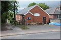
9
Telecoms cabinets, Manson's Cross, Monmouth
Viewed across the A466 Hereford Road in August 2016.
A label on the larger cabinet states 'Fibre broadband is here'.
Only the smaller cabinet appears in a June 2011 Google Earth Street View.
Image: © Jaggery
Taken: 21 Aug 2016
0.04 miles
10
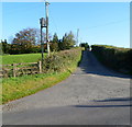
Manson's Lane, Monmouth
Viewed across the A466. Manson's Lane leads to Leasbrook Lane and Dixton.
There is a QV Foods trailer http://www.geograph.org.uk/photo/2662308 parked outside a depot at the top of the hill.
Image: © Jaggery
Taken: 22 Oct 2011
0.04 miles