IMAGES TAKEN NEAR TO
St. Thomas Square, MONMOUTH, NP25 5ES
Introduction
This page details the photographs taken nearby to St. Thomas Square, NP25 5ES by members of the Geograph project.
The Geograph project started in 2005 with the aim of publishing, organising and preserving representative images for every square kilometre of Great Britain, Ireland and the Isle of Man.

There are currently over 7.5m images from over14,400 individuals and you can help contribute to the project by visiting https://www.geograph.org.uk
Image Map
Images are licensed for reuse under creativecommons.org/licenses/by-sa/2.0
Notes
- Clicking on the map will re-center to the selected point.
- The higher the marker number, the further away the image location is from the centre of the postcode.
Image Listing (777 Images Found)
Images are licensed for reuse under creativecommons.org/licenses/by-sa/2.0
Image
Details
Distance
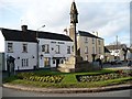
1
![Monmouth features [19]](https://s1.geograph.org.uk/geophotos/06/93/31/6933169_67e4cf23_120x120.jpg)
Monmouth features [19]
In St Thomas's Square is this unusual tree house.
Monmouth is a market town at the confluence of the Rivers Monnow and Wye some 30 miles northeast of Cardiff. Although there is evidence of settlement in the Neolithic period, the town was established around the Norman castle which was the birthplace of King Henry V. The historic county town of Monmouthshire, the town is now a centre for Wye Valley tourism.
Image: © Michael Dibb
Taken: 28 May 2021
0.00 miles
2
![Monmouth houses [4]](https://s0.geograph.org.uk/geophotos/06/93/31/6933180_ac9989f0_120x120.jpg)
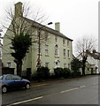
Monmouth houses [4]
Overmonnow House, number 21 St Thomas's Square was built circa 1700 and refronted in the early 19th century. Somewhat altered in the 19th and 20th centuries. Constructed of stuccoed rubble stone under a tile roof. This was the rectory for the church of St Thomas a Becket for many years. Listed, grade II, with details at: https://cadwpublic-api.azurewebsites.net/reports/listedbuilding/FullReport?lang=&id=2357
Monmouth is a market town at the confluence of the Rivers Monnow and Wye some 30 miles northeast of Cardiff. Although there is evidence of settlement in the Neolithic period, the town was established around the Norman castle which was the birthplace of King Henry V. The historic county town of Monmouthshire, the town is now a centre for Wye Valley tourism.
Image: © Michael Dibb
Taken: 28 May 2021
0.00 miles
3
![Monmouth features [20]](https://s1.geograph.org.uk/geophotos/06/93/31/6933181_3cd8020a_120x120.jpg)
Monmouth features [20]
An information board regarding the history of Overmonnow.
Monmouth is a market town at the confluence of the Rivers Monnow and Wye some 30 miles northeast of Cardiff. Although there is evidence of settlement in the Neolithic period, the town was established around the Norman castle which was the birthplace of King Henry V. The historic county town of Monmouthshire, the town is now a centre for Wye Valley tourism.
Image: © Michael Dibb
Taken: 28 May 2021
0.00 miles
4
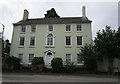
Overmonnow House, St Thomas's Square, Cinderhill Street, Monmouth
Dating from c1700, refronted in the early 19th century, this house was St Thomas's Rectory for many years.
The Church of St Thomas the Martyr http://www.geograph.org.uk/photo/670769 is on the opposite side of the road.
Overmonnow House was Grade II listed in 1952.
Image: © Jaggery
Taken: 8 Jan 2017
0.00 miles
5
Overmonnow House
Refronted house of c1700 http://cadwpublic-api.azurewebsites.net/reports/listedbuilding/FullReport?lang=en&id=2357
Image: © Jonathan Thacker
Taken: 12 Sep 2018
0.00 miles
6
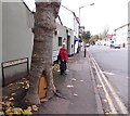
Entrance to a tree house in St Thomas's Square, Monmouth
The estate agent said the property was "compact", but this is ridiculous...
Image: © Jaggery
Taken: 26 Oct 2014
0.01 miles
7
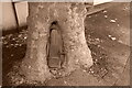
Door in tree, Over Monnow
A plane tree opposite the church shown in Image For some reason my camera has switched into monochrome again, as it did the previous day Image You can see a colour version, in sunshine too, at Image, so it's been there a while, although the door does seem to have been replaced - thanks to Penny Mayes for pointing this out.
Image: © Derek Harper
Taken: 25 Jun 2021
0.01 miles
8
Roundabout and Green Dragon Inn, Overmonnow
Situated on the Rockfield Road adjacent to Monnow Bridge.
Image: © Robin Drayton
Taken: 26 Jan 2008
0.01 miles
9
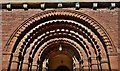
Monmouth, Overmonnow: The west entrance to the church of St. Thomas the Martyr
Image: © Michael Garlick
Taken: 12 Aug 2015
0.01 miles
10
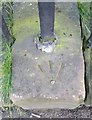
Ordnance Survey Rivet
This OS rivet can be found on the wall of St Thomas Church. It marks a point 17.663m above mean sea level.
Image: © Adrian Dust
Taken: 30 Jan 2019
0.01 miles