IMAGES TAKEN NEAR TO
The Hendre, MONMOUTH, NP25 5EP
Introduction
This page details the photographs taken nearby to NP25 5EP by members of the Geograph project.
The Geograph project started in 2005 with the aim of publishing, organising and preserving representative images for every square kilometre of Great Britain, Ireland and the Isle of Man.

There are currently over 7.5m images from over14,400 individuals and you can help contribute to the project by visiting https://www.geograph.org.uk
Image Map
Images are licensed for reuse under creativecommons.org/licenses/by-sa/2.0
Notes
- Clicking on the map will re-center to the selected point.
- The higher the marker number, the further away the image location is from the centre of the postcode.
Image Listing (6 Images Found)
Images are licensed for reuse under creativecommons.org/licenses/by-sa/2.0
Image
Details
Distance
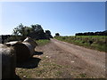
2
Rolling Monmouthshire countryside
Looking south from near Cefn-garw Farm.
Image: © Jonathan Billinger
Taken: 19 Aug 2008
0.16 miles
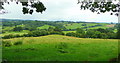
3
View north from Cefn Wood
In the blue distance is Edmund's Tump (left - 423m) and Garway Hill (above right hand sheep) in Herefordshire, (366m).
Image: © Jonathan Billinger
Taken: 19 Aug 2008
0.16 miles
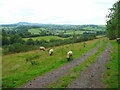
4

'Who Do You Think You Are?'
An oak tree on a hill above a small valley near Pen-yr-Heol is reminiscent of the tree used by the BBC in their family history series, 'Who Do You Think You Are?'
Image: © Philip Halling
Taken: 13 Nov 2011
0.21 miles
5
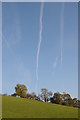
Vapour trails across the sky
Aircraft vapour trails across the sky above the Monmouthshire countryside.
Image: © Philip Halling
Taken: 13 Nov 2011
0.22 miles
6
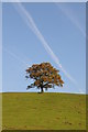
Vapour trails above an oak tree
Vapour trails above an oak tree standing on the brow of a hill near Tregare Mill.
Image: © Philip Halling
Taken: 13 Nov 2011
0.22 miles