IMAGES TAKEN NEAR TO
Caxton View, MONMOUTH, NP25 5DJ
Introduction
This page details the photographs taken nearby to Caxton View, NP25 5DJ by members of the Geograph project.
The Geograph project started in 2005 with the aim of publishing, organising and preserving representative images for every square kilometre of Great Britain, Ireland and the Isle of Man.

There are currently over 7.5m images from over14,400 individuals and you can help contribute to the project by visiting https://www.geograph.org.uk
Image Map
Images are licensed for reuse under creativecommons.org/licenses/by-sa/2.0
Notes
- Clicking on the map will re-center to the selected point.
- The higher the marker number, the further away the image location is from the centre of the postcode.
Image Listing (10 Images Found)
Images are licensed for reuse under creativecommons.org/licenses/by-sa/2.0
Image
Details
Distance
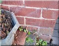
1
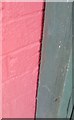
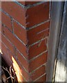
Ordnance Survey Cut Mark
This edge of this OS cut mark can be found on No18 Brook Crescent. It marks a point 22.174m above mean sea level.
Image: © Adrian Dust
Taken: 30 Jan 2019
0.09 miles
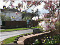
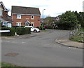
2
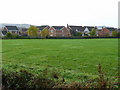
Recently-built housing
Part of the Brook estate on the western edge of Monmouth, viewed from the Rockfield Road.
Image: © Jonathan Billinger
Taken: 24 Oct 2008
0.12 miles
3
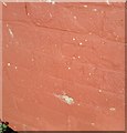
Ordnance Survey Cut Mark
This OS cut mark can be found on No1 Brook Crescent. It marks a point 21.652m above mean sea level.
Image: © Adrian Dust
Taken: 30 Jan 2019
0.16 miles
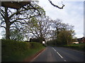
4
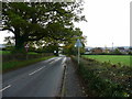
B4233 Rockfield Road
Approaching Monmouth from the north-west.
Image: © Jonathan Billinger
Taken: 24 Oct 2008
0.18 miles
5
Ordnance Survey Cut Mark
This OS cut mark can be found on No18 Rolls Avenue. It marks a point 21.567m above mean sea level.
Image: © Adrian Dust
Taken: 30 Jan 2019
0.19 miles
7
Phone box in Rolls Avenue
Viewed from Rockfield Road.
Image: © Pauline E
Taken: 7 Apr 2009
0.23 miles
8
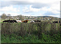
Cattle sunning off Rockfield Road
South of Drybridge Farm.
Image: © Pauline E
Taken: 7 Apr 2009
0.24 miles
9
North along Cornpoppy Avenue, Monmouth
Viewed across Chartist Rise. The bilingual name sign on the left
shows that Cornpoppy Avenue is Rhodfa Blodau'r Wig in Welsh.
Image: © Jaggery
Taken: 18 Aug 2020
0.24 miles
10
Ordnance Survey Cut Mark
This OS cut mark can be found on No47 Rockfield Road. It marks a point 21.455m above mean sea level.
Image: © Adrian Dust
Taken: 30 Jan 2019
0.24 miles