IMAGES TAKEN NEAR TO
Fitzroy Close, MONMOUTH, NP25 5BJ
Introduction
This page details the photographs taken nearby to Fitzroy Close, NP25 5BJ by members of the Geograph project.
The Geograph project started in 2005 with the aim of publishing, organising and preserving representative images for every square kilometre of Great Britain, Ireland and the Isle of Man.

There are currently over 7.5m images from over14,400 individuals and you can help contribute to the project by visiting https://www.geograph.org.uk
Image Map
Images are licensed for reuse under creativecommons.org/licenses/by-sa/2.0
Notes
- Clicking on the map will re-center to the selected point.
- The higher the marker number, the further away the image location is from the centre of the postcode.
Image Listing (533 Images Found)
Images are licensed for reuse under creativecommons.org/licenses/by-sa/2.0
Image
Details
Distance
1
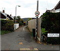
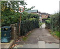
Footpath towards Clawdd-du Bridge, Monmouth
The sign shows No Cycling along this footpath to ancient Clawdd-du Bridge. http://www.geograph.org.uk/photo/4274903
The path marks the point where Elstob Way to the south becomes Fitzroy Close to the north.
Image: © Jaggery
Taken: 26 Oct 2014
0.01 miles
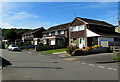
2
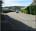
Fitzroy Close, Monmouth
Viewed from the corner of Wonastow Road.
Image: © Jaggery
Taken: 12 Jul 2020
0.02 miles
3
Hedges and houses in Fitzroy Close, Monmouth
Viewed from Wonastow Road.
Image: © Jaggery
Taken: 26 Oct 2014
0.03 miles
4
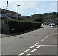
Long hedge, Elstob Way, Monmouth
Extending for 30 metres to the corner of Port Mahon Close.
Image: © Jaggery
Taken: 12 Jul 2020
0.03 miles
5
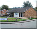
Monmouth : Goldwire Lane bungalows
Viewed from the corner of Somerset Road.
Image: © Jaggery
Taken: 12 Sep 2010
0.03 miles
6
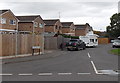
Port Mahon Close, Monmouth
Cul-de-sac on the east side of Elstob Way.
Image: © Jaggery
Taken: 26 Oct 2014
0.03 miles
7
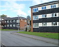
Flats, Somerset Road, Monmouth
The buildings date from c1960.
Image: © Jaggery
Taken: 12 Sep 2010
0.04 miles
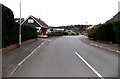
8
Elstob Way houses, Monmouth
Looking to the south in July 2020.
Image: © Jaggery
Taken: 12 Jul 2020
0.04 miles
9
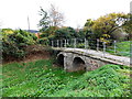
Grade II* listed Clawdd-du Bridge, Monmouth
Located on a path between Goldwire Lane and Fitzroy Close, the medieval footbridge spans the ditch which once provided the outer defences of the faubourg of Overmonnow, and through which the waters of the River Monnow could be diverted in times of threat. A faubourg was the area just beyond the town walls. The bridge was Grade II* listed in 1974 and is also a Scheduled Ancient Monument.
Image: © Jaggery
Taken: 26 Oct 2014
0.04 miles
10
No cycling across Clawdd-du Bridge, Monmouth
Viewed from Goldwire Lane on the approach to this http://www.geograph.org.uk/photo/4274903 medieval bridge.
Image: © Jaggery
Taken: 26 Oct 2014
0.04 miles