IMAGES TAKEN NEAR TO
Victoria Estate, MONMOUTH, NP25 5AR
Introduction
This page details the photographs taken nearby to Victoria Estate, NP25 5AR by members of the Geograph project.
The Geograph project started in 2005 with the aim of publishing, organising and preserving representative images for every square kilometre of Great Britain, Ireland and the Isle of Man.

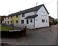
There are currently over 7.5m images from over14,400 individuals and you can help contribute to the project by visiting https://www.geograph.org.uk
Image Map
Images are licensed for reuse under creativecommons.org/licenses/by-sa/2.0
Notes
- Clicking on the map will re-center to the selected point.
- The higher the marker number, the further away the image location is from the centre of the postcode.
Image Listing (281 Images Found)
Images are licensed for reuse under creativecommons.org/licenses/by-sa/2.0
Image
Details
Distance
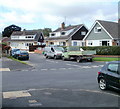
1
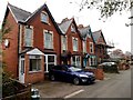
Primrose Villas, Monmouth
Viewed from a footpath through the Victoria Estate.
Image: © Jaggery
Taken: 26 Oct 2014
0.01 miles
2
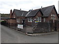
Overmonnow Family Learning Centre, Monmouth
Located in the Victoria Estate, the Centre runs courses in subjects such as computers,
arts & crafts, languages and essential skills (improve your Maths and English etc).
In October 2014, temporary fencing encloses a partially collapsed perimeter wall.
Image: © Jaggery
Taken: 26 Oct 2014
0.05 miles
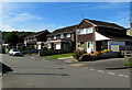
3
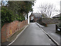
Over Monnow Family Learning Centre
Victoria Estate, just off Wonastow Road.
Image: © Pauline E
Taken: 7 Apr 2009
0.05 miles
4
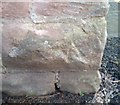
Ordnance Survey Cut Mark
This remains of this OS cut mark can be found on the west angle of the school. It marked a point 18.037m above mean sea level.
Image: © Adrian Dust
Taken: 30 Jan 2019
0.05 miles
5
Fitzroy Close, Monmouth
Viewed from the corner of Elstob Way.
Image: © Jaggery
Taken: 12 Sep 2010
0.06 miles
6
Elstob Way houses, Monmouth
Looking to the south in July 2020.
Image: © Jaggery
Taken: 12 Jul 2020
0.06 miles
7
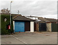
Postbox and sign in a hedge, Victoria Estate, Monmouth
Opposite Overmonnow Family Learning Centre. http://www.geograph.org.uk/photo/4275764
Image: © Jaggery
Taken: 26 Oct 2014
0.06 miles
8
Elstob Way towards Fitzroy Close, Monmouth
A suburban view in the Overmonnow area of Monmouth.
Image: © Jaggery
Taken: 26 Oct 2014
0.06 miles
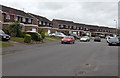
9
Lockwood Row, Monmouth
Part of the Victoria Estate, Lockwood Row is on the south side of Wonastow Road.
Image: © Jaggery
Taken: 26 Oct 2014
0.06 miles
10
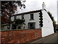
Former Victoria Inn, Monmouth
An inscription on the side wall of this house set back 20 metres from Wonastow Road shows
VICTORIA INN 1864.
Image: © Jaggery
Taken: 26 Oct 2014
0.07 miles