IMAGES TAKEN NEAR TO
Goldwire Lane, MONMOUTH, NP25 5AG
Introduction
This page details the photographs taken nearby to Goldwire Lane, NP25 5AG by members of the Geograph project.
The Geograph project started in 2005 with the aim of publishing, organising and preserving representative images for every square kilometre of Great Britain, Ireland and the Isle of Man.

There are currently over 7.5m images from over14,400 individuals and you can help contribute to the project by visiting https://www.geograph.org.uk
Image Map
Images are licensed for reuse under creativecommons.org/licenses/by-sa/2.0
Notes
- Clicking on the map will re-center to the selected point.
- The higher the marker number, the further away the image location is from the centre of the postcode.
Image Listing (694 Images Found)
Images are licensed for reuse under creativecommons.org/licenses/by-sa/2.0
Image
Details
Distance
1
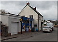
Best One in Monmouth
Convenience store in Goldwire Lane.
Image: © Jaggery
Taken: 26 Oct 2014
0.00 miles
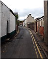
2
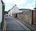
Goldwire Lane, Monmouth
Goldwire Lane heads SW away from Drybridge Street.
Image: © Jaggery
Taken: 12 Sep 2010
0.03 miles
3
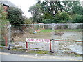
Danger - keep out, Goldwire Lane, Monmouth
It is not obvious exactly what danger is present in this small, fenced-off vacant area on the SE side of Goldwire Lane.
Image: © Jaggery
Taken: 12 Sep 2010
0.03 miles
4
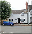
St Gwithian Cottage, Monmouth
Located on Drybridge Street.
Image: © Jaggery
Taken: 12 Sep 2010
0.03 miles
5
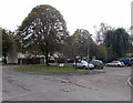
Trees in Waldbronn Close, Monmouth
Viewed from Goldwire Lane. Situated in the northern Black Forest,
SW Germany, Waldbronn is one of Monmouth's twin towns.
Image: © Jaggery
Taken: 26 Oct 2014
0.03 miles
6
Waldbronn Close, Monmouth
Viewed from Goldwire Lane. Situated in the northern Black Forest,
SW Germany, Waldbronn is one of Monmouth's twin towns.
Image: © Jaggery
Taken: 26 Oct 2014
0.03 miles
7
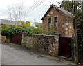
The Old School House, Monmouth
On the east side of Goldwire Lane.
Image: © Jaggery
Taken: 26 Oct 2014
0.04 miles
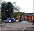
8
Bungalows and a water-filled pothole near Clawdd-du Bridge, Monmouth
Located at the SW edge of Goldwire Lane, near this http://www.geograph.org.uk/photo/4274903 medieval bridge.
Image: © Jaggery
Taken: 26 Oct 2014
0.04 miles
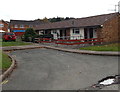
9
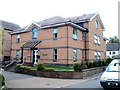
Abbeyfield House, Monmouth
Abbeyfield House, built in 1993, contains 10 flats. Tenure is rented (social landlord). Support is available from resident management staff. There is a community alarm service. Located on Goldwire Lane.
Image: © Jaggery
Taken: 12 Sep 2010
0.04 miles
10
No parking in Goldwire Lane, Monmouth
Goldwire Lane heads SW away from Drybridge Street. There is a one-way traffic flow in force here (towards the camera) and double yellows on both sides of the lane make parking illegal.
Image: © Jaggery
Taken: 26 Oct 2014
0.05 miles