IMAGES TAKEN NEAR TO
Glenroyd Terrace, MONMOUTH, NP25 5AE
Introduction
This page details the photographs taken nearby to Glenroyd Terrace, NP25 5AE by members of the Geograph project.
The Geograph project started in 2005 with the aim of publishing, organising and preserving representative images for every square kilometre of Great Britain, Ireland and the Isle of Man.

There are currently over 7.5m images from over14,400 individuals and you can help contribute to the project by visiting https://www.geograph.org.uk
Image Map
Images are licensed for reuse under creativecommons.org/licenses/by-sa/2.0
Notes
- Clicking on the map will re-center to the selected point.
- The higher the marker number, the further away the image location is from the centre of the postcode.
Image Listing (734 Images Found)
Images are licensed for reuse under creativecommons.org/licenses/by-sa/2.0
Image
Details
Distance
1
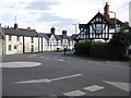
Mini roundabout, Overmonnow
With some pleasant, timbered buildings.
Image: © Pauline E
Taken: 20 Feb 2009
0.01 miles
2
![Monmouth houses [6]](https://s3.geograph.org.uk/geophotos/06/93/41/6934119_e92fe98d_120x120.jpg)
Monmouth houses [6]
Number 6 Drybridge Street, on the left of the image, is a single bay of a three bay 17th century house, number 8 Drybridge Street is the other two bays. The house was refronted in the 18th century with the gable added at that time and divided into two properties. The walls are rendered and painted and possibly conceal some timber framing, all under a tile roof. The building was once a public house. Listed, grade II, with details at: https://cadwpublic-api.azurewebsites.net/reports/listedbuilding/FullReport?lang=&id=85144 (number 6) and at: https://cadwpublic-api.azurewebsites.net/reports/listedbuilding/FullReport?lang=&id=85165 (number 8).
Monmouth is a market town at the confluence of the Rivers Monnow and Wye some 30 miles northeast of Cardiff. Although there is evidence of settlement in the Neolithic period, the town was established around the Norman castle which was the birthplace of King Henry V. The historic county town of Monmouthshire, the town is now a centre for Wye Valley tourism.
Image: © Michael Dibb
Taken: 28 May 2021
0.01 miles
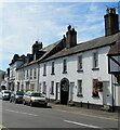
3
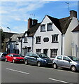
Three storey house, Drybridge Street, Monmouth
Grade II Listed former pub.
Image: © Jaggery
Taken: 12 Jul 2020
0.01 miles
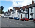
4
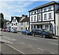
Drybridge Street houses and cars, Monmouth
Several Grade II Listed buildings are in view.
Image: © Jaggery
Taken: 12 Jul 2020
0.01 miles
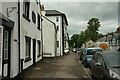
5
Glenroyd Terrace name sign, Monmouth
On the corner of Drybridge Street.
Image: © Jaggery
Taken: 12 Jul 2020
0.01 miles
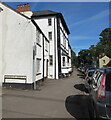
6
Grade II Listed buildings, Drybridge Street, Monmouth
A few of many Listed buildings in Drybridge Street.
Image: © Jaggery
Taken: 12 Jul 2020
0.02 miles
7
Drybridge Street, Monmouth
A little way ahead, Glenroyd Terrace turns off left. There are several listed buildings on the street (the B4233, used here by the Offa's Dyke Path), the three-storey one jutting out ahead being described at https://cadwpublic-api.azurewebsites.net/reports/listedbuilding/FullReport?lang=&id=2255 .
Image: © Derek Harper
Taken: 25 Jun 2021
0.02 miles
8
![Monmouth houses [5]](https://s3.geograph.org.uk/geophotos/06/93/41/6934115_54a350f7_120x120.jpg)
Monmouth houses [5]
Number 4 Drybridge Street has 17th century origins but has been greatly altered and extended in the late 20th century. The walls are now rendered and painted, probably concealing some timber framing, all under a Welsh slate roof. Listed, grade II, with details at: https://cadwpublic-api.azurewebsites.net/reports/listedbuilding/FullReport?lang=&id=2255
Monmouth is a market town at the confluence of the Rivers Monnow and Wye some 30 miles northeast of Cardiff. Although there is evidence of settlement in the Neolithic period, the town was established around the Norman castle which was the birthplace of King Henry V. The historic county town of Monmouthshire, the town is now a centre for Wye Valley tourism.
Image: © Michael Dibb
Taken: 28 May 2021
0.02 miles
9
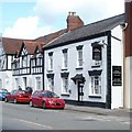
Three Horseshoes, Monmouth
Pub at 21 Drybridge Street, in a row of Tudoresque houses. http://www.geograph.org.uk/photo/2069186
Image: © Jaggery
Taken: 12 Sep 2010
0.02 miles
10
Tudoresque houses, Drybridge Street, Monmouth
Located on the NE section of Drybridge Street.
Image: © Jaggery
Taken: 12 Sep 2010
0.02 miles