IMAGES TAKEN NEAR TO
Whitebrook, MONMOUTH, NP25 4TY
Introduction
This page details the photographs taken nearby to NP25 4TY by members of the Geograph project.
The Geograph project started in 2005 with the aim of publishing, organising and preserving representative images for every square kilometre of Great Britain, Ireland and the Isle of Man.

There are currently over 7.5m images from over14,400 individuals and you can help contribute to the project by visiting https://www.geograph.org.uk
Image Map
Images are licensed for reuse under creativecommons.org/licenses/by-sa/2.0
Notes
- Clicking on the map will re-center to the selected point.
- The higher the marker number, the further away the image location is from the centre of the postcode.
Image Listing (6 Images Found)
Images are licensed for reuse under creativecommons.org/licenses/by-sa/2.0
Image
Details
Distance
1
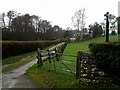
Private drive near New Mills
Not a public right of way.
Image: © Jonathan Billinger
Taken: 18 Dec 2018
0.02 miles
2
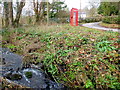
The White Brook at New Mills
The lane beyond heads for The Argoed.
Image: © Jonathan Billinger
Taken: 8 Feb 2012
0.09 miles
5
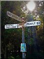
Direction Sign ? Signpost
Located on the southwest side of the crossroads one mile northwest of The Narth in Trellech United community. 4 arms and no finial.
Milestone Society National ID: MON_SO5107
Image: © Jimmy Kawasaki
Taken: 26 Aug 2019
0.22 miles
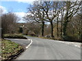
6

Country crossroads
Looking from the Penallt direction, with Whitebrook left, Narth and Trellech (Trelleck on the sign) straight over, and Monmouth right.
Image: © Robin Webster
Taken: 6 Jun 2023
0.22 miles