IMAGES TAKEN NEAR TO
Whitebrook, MONMOUTH, NP25 4TT
Introduction
This page details the photographs taken nearby to NP25 4TT by members of the Geograph project.
The Geograph project started in 2005 with the aim of publishing, organising and preserving representative images for every square kilometre of Great Britain, Ireland and the Isle of Man.

There are currently over 7.5m images from over14,400 individuals and you can help contribute to the project by visiting https://www.geograph.org.uk
Image Map
Images are licensed for reuse under creativecommons.org/licenses/by-sa/2.0
Notes
- Clicking on the map will re-center to the selected point.
- The higher the marker number, the further away the image location is from the centre of the postcode.
Image Listing (60 Images Found)
Images are licensed for reuse under creativecommons.org/licenses/by-sa/2.0
Image
Details
Distance
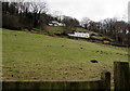
1
Sheep in a Whitebrook field
Viewed from the main road through Whitebrook, a small village at the eastern edge of Monmouthshire.
Image: © Jaggery
Taken: 1 Feb 2015
0.01 miles
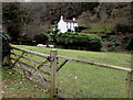
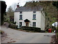
2
Farm house at Whitebrook
A handsome place.
Image: © Jeremy Bolwell
Taken: 30 May 2016
0.01 miles
3
Molehills in a Whitebrook field
Viewed from the main road through Whitebrook, a small village at the eastern edge of Monmouthshire.
Image: © Jaggery
Taken: 1 Feb 2015
0.06 miles
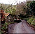
4
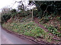
Hillside track, Whitebrook
Near Whitebrook Farm. http://www.geograph.org.uk/photo/4567490
Image: © Jaggery
Taken: 1 Feb 2015
0.08 miles
5
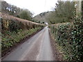
West through Whitebrook
The main road through Whitebrook, a small village at the eastern edge of Monmouthshire.
Image: © Jaggery
Taken: 1 Feb 2015
0.08 miles
6
Passing place on the main road through Whitebrook
Whitebrook is a small village at the eastern edge of Monmouthshire
Image: © Jaggery
Taken: 1 Feb 2015
0.08 miles
7
The Bell, Whitebrook
The former pub has been in residential use for several decades. One source states that the pub closed in 1962.
Image: © Jaggery
Taken: 1 Feb 2015
0.08 miles
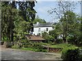
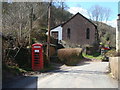
8

Manor Brook Cottage, Whitebrook
The postbox in the wall is from the reign of King George V. http://www.geograph.org.uk/photo/4567639
Image: © Jaggery
Taken: 1 Feb 2015
0.09 miles
10
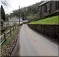
ESE along the main road through Whitebrook
Whitebrook is a small village at the eastern edge of Monmouthshire.
White Brook, a tributary of the River Wye, flows below the railings on the left.
Now a holiday cottage, Old Trinity Church http://www.geograph.org.uk/photo/4568522 is on the right.
The red object in the background is a former telephone box. http://www.geograph.org.uk/photo/4567623
Image: © Jaggery
Taken: 1 Feb 2015
0.09 miles