IMAGES TAKEN NEAR TO
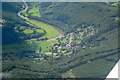
Llandogo, MONMOUTH, NP25 4TB
Introduction
This page details the photographs taken nearby to NP25 4TB by members of the Geograph project.
The Geograph project started in 2005 with the aim of publishing, organising and preserving representative images for every square kilometre of Great Britain, Ireland and the Isle of Man.

There are currently over 7.5m images from over14,400 individuals and you can help contribute to the project by visiting https://www.geograph.org.uk
Image Map
Images are licensed for reuse under creativecommons.org/licenses/by-sa/2.0
Notes
- Clicking on the map will re-center to the selected point.
- The higher the marker number, the further away the image location is from the centre of the postcode.
Image Listing (96 Images Found)
Images are licensed for reuse under creativecommons.org/licenses/by-sa/2.0
Image
Details
Distance
2
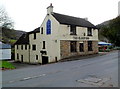
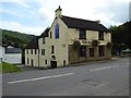
The Sloop Inn, Llandogo
Located alongside the A466. A stone plaque on the back of the building shows 1707, the date of the construction of the original cider house and mill. A white-on-blue notice on the side wall states that en-suite accommodation is available. There is a beer garden.
The name of the inn is a reference to the sloops (small one-masted vessels) that formerly traded along the River Wye in this area.
Image: © Jaggery
Taken: 4 Dec 2011
0.03 miles
3
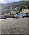
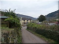
The Sloop Inn Car Park, Llandogo, Monmouthshire
On the west side of the A466, the main road through the village.
The Sloop Inn is on the opposite side of the A466.
Image: © Jaggery
Taken: 3 Mar 2024
0.03 miles
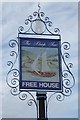
5
The Sloop Inn
The Sloop Inn in Llandogo.
Image: © Philip Halling
Taken: 10 Aug 2017
0.03 miles
6
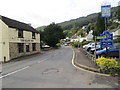
View to the Sloop Inn, Llandogo
A well known landmark in the Wye Valley, this roadside pub seems to be readily and fondly remembered by many people, maybe because of its memorable name, its location or its good standards of hospitality over many years.
Image: © Jeremy Bolwell
Taken: 24 Feb 2013
0.04 miles
7
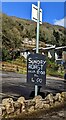
Sunday Roast information, Llandogo, Monmouthshire
In the Sloop Inn car park, facing the A466.
The Sloop Inn is on the opposite side of the A466.
Image: © Jaggery
Taken: 3 Mar 2024
0.04 miles
8
Road (A466) at the Sloop Inn in Llandogo
Looking south-westward.
Image: © Peter Wood
Taken: 17 Oct 2016
0.04 miles
9
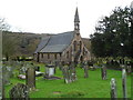
Church of St Oudoceus, Llandogo
Church in Wales church set back about 60 metres from the A466. Various references spell the name 'Oedoceus' but 'Oudoceus' is shown on the church board at the entrance. The Welsh form of Oudoceus is Euddogwy. Llandogo is a semi-anglicised form of the Welsh name of the village, Llaneuddogwy. Some references state that Oudoceus was the third Bishop of Llandaff, who probably lived in this area in the 6th or 7th century.
The church was built during 1859-1861 on the site of a much earlier church. An unusual feature of the church, seen here, is the pulpit-like bellcote.
Image: © Jaggery
Taken: 4 Dec 2011
0.04 miles
10
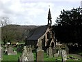
Llandogo, Church of St Oedoceus
http://www.churchcrawler.pwp.blueyonder.co.uk/churchcrawler/gwent.htm
Image: © ChurchCrawler
Taken: 21 Mar 2002
0.04 miles