IMAGES TAKEN NEAR TO
Penallt, MONMOUTH, NP25 4RZ
Introduction
This page details the photographs taken nearby to NP25 4RZ by members of the Geograph project.
The Geograph project started in 2005 with the aim of publishing, organising and preserving representative images for every square kilometre of Great Britain, Ireland and the Isle of Man.

There are currently over 7.5m images from over14,400 individuals and you can help contribute to the project by visiting https://www.geograph.org.uk
Image Map
Images are licensed for reuse under creativecommons.org/licenses/by-sa/2.0
Notes
- Clicking on the map will re-center to the selected point.
- The higher the marker number, the further away the image location is from the centre of the postcode.
Image Listing (6 Images Found)
Images are licensed for reuse under creativecommons.org/licenses/by-sa/2.0
Image
Details
Distance
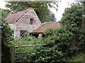
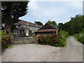
1
Monmouthshire lane near Tre-gagle
One of my fave areas in this blessed county.
Image: © Jeremy Bolwell
Taken: 30 May 2016
0.06 miles
3
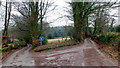
Lanes divide
Left ends in forestry above Whitebrook, right leads to Trellech and civilisation!
Image: © Jonathan Billinger
Taken: 8 Feb 2012
0.16 miles
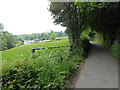
5
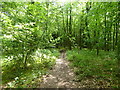
Footpath into the woods
Nice May walking.
Image: © Jeremy Bolwell
Taken: 30 May 2016
0.18 miles