IMAGES TAKEN NEAR TO
The Narth, MONMOUTH, NP25 4RA
Introduction
This page details the photographs taken nearby to NP25 4RA by members of the Geograph project.
The Geograph project started in 2005 with the aim of publishing, organising and preserving representative images for every square kilometre of Great Britain, Ireland and the Isle of Man.

There are currently over 7.5m images from over14,400 individuals and you can help contribute to the project by visiting https://www.geograph.org.uk
Image Map (Loading...)


Getting Data...Please wait
Leaflet Map data © OpenStreetMap
Images are licensed for reuse under creativecommons.org/licenses/by-sa/2.0
Notes
- Clicking on the map will re-center to the selected point.
- The higher the marker number, the further away the image location is from the centre of the postcode.
Image Listing (6 Images Found)
Images are licensed for reuse under creativecommons.org/licenses/by-sa/2.0
Image
Details
Distance
1

Smiley face in a hedge
A smiley face cut into a hedge near Whitebrook.
Image: © Philip Halling
Taken: 2 Jun 2022
0.02 miles
2
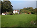
Cottage at Pen-y-fan
Cottage and garden above the Wye valley at Pen-y-fan.
Image: © Philip Halling
Taken: 15 Oct 2006
0.09 miles
3
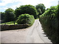
The lane past the entrance to Dukes House
The Wye Valley Walk follows this lane for about 200 metres.
Image: © David Purchase
Taken: 10 Jul 2015
0.11 miles
5
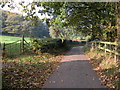
Country lane at Pen-y-fan
The Wye Valley Walk follows this quiet lane at Pen-y-fan.
Image: © Philip Halling
Taken: 15 Oct 2006
0.17 miles
6
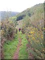
Struggling up the hillside
A walker on the steep path that ascends the hillside above the River Wye near Pilstone Farm.
Image: © Gordon Hatton
Taken: 17 Oct 2011
0.19 miles