IMAGES TAKEN NEAR TO
Woodlands, MONMOUTH, NP25 4QT
Introduction
This page details the photographs taken nearby to Woodlands, NP25 4QT by members of the Geograph project.
The Geograph project started in 2005 with the aim of publishing, organising and preserving representative images for every square kilometre of Great Britain, Ireland and the Isle of Man.

There are currently over 7.5m images from over14,400 individuals and you can help contribute to the project by visiting https://www.geograph.org.uk
Image Map
Images are licensed for reuse under creativecommons.org/licenses/by-sa/2.0
Notes
- Clicking on the map will re-center to the selected point.
- The higher the marker number, the further away the image location is from the centre of the postcode.
Image Listing (4 Images Found)
Images are licensed for reuse under creativecommons.org/licenses/by-sa/2.0
Image
Details
Distance
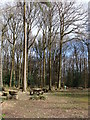
2
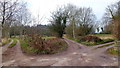
Three-way split
Diverging tracks to the west of The Narth.
Image: © Jonathan Billinger
Taken: 8 Feb 2012
0.12 miles
3
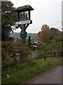
The Trekkers at The Narth
An unusual pub in the small village of The Narth above the Wye valley.
Image: © Philip Halling
Taken: 15 Oct 2006
0.14 miles
4
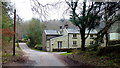
Stone house at Manorside
This lane does a loop and represents the way in and way out of the community of Pen-y-fan.
Image: © Jonathan Billinger
Taken: 8 Feb 2012
0.24 miles