IMAGES TAKEN NEAR TO
The Narth, MONMOUTH, NP25 4QP
Introduction
This page details the photographs taken nearby to NP25 4QP by members of the Geograph project.
The Geograph project started in 2005 with the aim of publishing, organising and preserving representative images for every square kilometre of Great Britain, Ireland and the Isle of Man.

There are currently over 7.5m images from over14,400 individuals and you can help contribute to the project by visiting https://www.geograph.org.uk
Image Map
Images are licensed for reuse under creativecommons.org/licenses/by-sa/2.0
Notes
- Clicking on the map will re-center to the selected point.
- The higher the marker number, the further away the image location is from the centre of the postcode.
Image Listing (4 Images Found)
Images are licensed for reuse under creativecommons.org/licenses/by-sa/2.0
Image
Details
Distance
1
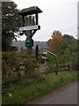
The Trekkers at The Narth
An unusual pub in the small village of The Narth above the Wye valley.
Image: © Philip Halling
Taken: 15 Oct 2006
0.09 miles
2
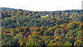
View towards The Narth from Coxbury Farm, Wye Valley
Image: © Colin Park
Taken: 18 Oct 2022
0.13 miles
4
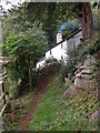
Isolated cottage above Whitebrook
A steep footpath climbs from Whitebrook to The Narth passing this cottage on the way. The cottage is in a wonderful position with views across the Wye valley to Gloucestershire and England.
Image: © Philip Halling
Taken: 15 Oct 2006
0.23 miles