IMAGES TAKEN NEAR TO
Warren Terrace, MONMOUTH, NP25 4PH
Introduction
This page details the photographs taken nearby to Warren Terrace, NP25 4PH by members of the Geograph project.
The Geograph project started in 2005 with the aim of publishing, organising and preserving representative images for every square kilometre of Great Britain, Ireland and the Isle of Man.

There are currently over 7.5m images from over14,400 individuals and you can help contribute to the project by visiting https://www.geograph.org.uk
Image Map
Images are licensed for reuse under creativecommons.org/licenses/by-sa/2.0
Notes
- Clicking on the map will re-center to the selected point.
- The higher the marker number, the further away the image location is from the centre of the postcode.
Image Listing (15 Images Found)
Images are licensed for reuse under creativecommons.org/licenses/by-sa/2.0
Image
Details
Distance
1
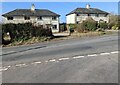
Four semis north of Trellech, Monmouthshire
Semi-detached houses on the west side of the B4293
Monmouth Road opposite the Warren's Road junction.
Image: © Jaggery
Taken: 27 Feb 2022
0.01 miles
2
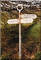
Maryland and Narth direction sign in rural Monmouthshire
The sign alongside the B4293 Monmouth Road
points towards Warren's Road. https://www.geograph.org.uk/photo/7106943
Image: © Jaggery
Taken: 27 Feb 2022
0.01 miles
3
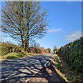
Deciduous trees near Trellech in late winter, Monmouthshire
Leafless trees viewed across the B4293 Monmouth Road on February 27th 2022.
This location is 240 metres (nearly 790 ft) above mean sea level.
Image: © Jaggery
Taken: 27 Feb 2022
0.02 miles
4

Sunday cyclist north of Trellech, Monmouthshire
Travelling north on the B4293 Monmouth Road on February 27th 2022.
Image: © Jaggery
Taken: 27 Feb 2022
0.02 miles
5
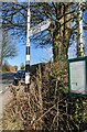
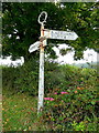
Direction Sign ? Signpost
Located on the northeast side of the T junction of the B4293 Monmouth Road and Warrens Road in Trellech United community. 3 arms and annulus finial. The Trelech arm was broken off by 2011. See also https://www.geograph.org.uk/photo/2624122.
Milestone Society National ID: MON_SO5006
Image: © W Marsh
Taken: 8 Jul 1991
0.02 miles
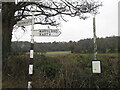
6
Old fingerpost sign
The Warrens Road take folks east from the Monmouth Road to The Narth and Maryland.
The broken arm would probably have indicated Trellech and Chepstow.
Image: © Jonathan Billinger
Taken: 23 Sep 2011
0.02 miles
7
Disused bus timetable noticeboard north of Trellech
Located here https://www.geograph.org.uk/photo/7106976 alongside the B4293 Monmouth Road near the corner of Warren's Road. In February 2022 a label on the board shows "THE 65 BUS NO LONGER STOPS HERE. All services now go via The Narth and Penallt".
Image: © Jaggery
Taken: 27 Feb 2022
0.02 miles
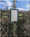
8
Monmouthshire County Council fingerpost
At the end of Warren's Road. This was the old Monmouthshire, the one which sort of hung in limbo between England and Wales - "Wales and Monmouthshire" was a phrase used a lot before 1974.
Image: © Richard Webb
Taken: 21 Mar 2022
0.02 miles
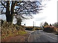
10
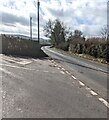
Junction north of Trellech, Monmouthshire
From the left, unclassified Warren's Road joins the B4293 Monmouth Road.
Image: © Jaggery
Taken: 27 Feb 2022
0.02 miles