1
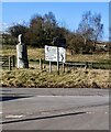
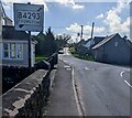
Old-style sign near a junction in Trellech
A black arrow points the way to Chepstow along the B4293. Catbrook Road is on the left.
Image: © Jaggery
Taken: 4 Mar 2012
0.01 miles
2
The Pound,Trellech
On the corner of Catbrook Road and Chepstow Road, The Pound was an agricultural building now converted for use as holiday accommodation.
Image: © Jaggery
Taken: 4 Mar 2012
0.01 miles
3
B4293 direction and distances signs facing Catbrook Road, Trellech
Left on the B4293 for Chepstow (9 (miles)). Right on the B4293 for (the centre of) Trellech (¼) and Monmouth (6).
Image: © Jaggery
Taken: 27 Feb 2022
0.01 miles
4
Trellech road junction
The main road curving right is the B4293 from Monmouth to Chepstow. The Catbrook road continues into the distance, through an area where an archaeological dig has revealed evidence of Trellech Town's former greater extent, on both sides of this road. The Cleddon road runs to the left, very near to the B4293.
Image: © Roy Parkhouse
Taken: 29 Jun 2007
0.01 miles
5
Cedar sculpture
With two sundials, sculpted by Neil Gow, positioned close to a road junction in Trellech.
Image: © Pauline E
Taken: 28 Oct 2008
0.02 miles
6
Old-style B4293 direction sign, Trellech
The B4293 bends to the right at the Catbrook Road junction.
Image: © Jaggery
Taken: 27 Feb 2022
0.02 miles
7
Junction of Llandogo Road and Catbrook Road, Trellech
Llandogo Road is on the left.
Image: © Jaggery
Taken: 4 Mar 2012
0.02 miles
8
The Wye Valley Practice, Trellech
Medical surgery located next door to Trellech Methodist Church. http://www.geograph.org.uk/photo/3903945
Image: © Jaggery
Taken: 4 Mar 2012
0.02 miles
9
Catbrook Road, Trellech
Image: © Roger Cornfoot
Taken: 19 Nov 2017
0.02 miles
10
Former pound
Now a dwelling, this stone building stands beside the B4293 on the southern end of the village of Trellech. This was once the village pound, for the safe enclosure of stray animals and drunken villagers. Recessed into its curved roadside wall are two water troughs fed by a spring which arises from the verge to the southeast near the Virtuous Well on the Cotland road. The larger trough was probably intended for larger animals and the small one for dogs. This road was the main route from Monmouth to Chepstow and weary travellers and their animals would stop here to drink.
Image: © Pauline E
Taken: 28 Oct 2008
0.03 miles


