IMAGES TAKEN NEAR TO
Roman Way, MONMOUTH, NP25 4NZ
Introduction
This page details the photographs taken nearby to Roman Way, NP25 4NZ by members of the Geograph project.
The Geograph project started in 2005 with the aim of publishing, organising and preserving representative images for every square kilometre of Great Britain, Ireland and the Isle of Man.

There are currently over 7.5m images from over14,400 individuals and you can help contribute to the project by visiting https://www.geograph.org.uk
Image Map
Images are licensed for reuse under creativecommons.org/licenses/by-sa/2.0
Notes
- Clicking on the map will re-center to the selected point.
- The higher the marker number, the further away the image location is from the centre of the postcode.
Image Listing (124 Images Found)
Images are licensed for reuse under creativecommons.org/licenses/by-sa/2.0
Image
Details
Distance
1
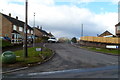
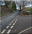
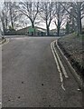
Roman Way, Trellech
Viewed from Monmouth Road. Roman Way leads to Roman Park View.
Trellech is also spelt Trelleck (Tryleg in Welsh)
Image: © Jaggery
Taken: 4 Mar 2012
0.07 miles
2
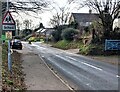
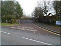
Warning sign - School, Trellech, Monmouthshire
Alongside the B4293 Monmouth Road on the approach to Trellech Primary School. A small Neighbourhood Watch Area sign is below the warning sign.
Image: © Jaggery
Taken: 27 Feb 2022
0.07 miles
3
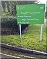
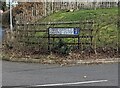
Bilingual school nameboard, Trellech, Monmouthshire
The board facing the B4293 Monmouth Road shows that
Trellech Primary School is Ysgol Gynradd Tryleg in Welsh.
Image: © Jaggery
Taken: 27 Feb 2022
0.07 miles
4
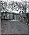
School entrance gates, Trellech, Monmouthshire
Facing the B4293 Monmouth Road at the entrance to Trellech Primary School.
Image: © Jaggery
Taken: 27 Feb 2022
0.08 miles
5
Junction of Monmouth Road and Harold Close, Trellech, Monmouthshire
From the right, Harold Close joins the B4293 Monmouth Road.
Image: © Jaggery
Taken: 27 Feb 2022
0.08 miles
6
Bilingual street name sign, Trellech, Monmouthshire
The sign located here https://www.geograph.org.uk/photo/7107144 shows that Harold Close is Clos Harold in Welsh.
Image: © Jaggery
Taken: 27 Feb 2022
0.08 miles
7
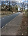
Monmouth Road pavement and roadway, Trellech, Monmouthshire
The B4293 Monmouth Road passes the Harold Close
junction in the background on the right.
Image: © Jaggery
Taken: 27 Feb 2022
0.08 miles
8
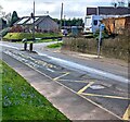
Zigzag yellow markings on Monmouth Road, Trellech
Marking the Keep Clear zone near Trellech Primary School.
The Roman Way junction is on the right.
Image: © Jaggery
Taken: 27 Feb 2022
0.08 miles
9
Into Trellech Primary School, Monmouthshire
Viewed from these https://www.geograph.org.uk/photo/7107138 gates in February 2022.
Image: © Jaggery
Taken: 27 Feb 2022
0.09 miles
10
Trellech Primary School exit
Viewed across Monmouth Road opposite Roman Way. http://www.geograph.org.uk/photo/3903453 A one-way system operates through the school grounds. The entrance road is 50 metres to the left (north) of the exit.
Image: © Jaggery
Taken: 4 Mar 2012
0.09 miles