IMAGES TAKEN NEAR TO
Wye's Green, MONMOUTH, NP25 4ND
Introduction
This page details the photographs taken nearby to Wye's Green, NP25 4ND by members of the Geograph project.
The Geograph project started in 2005 with the aim of publishing, organising and preserving representative images for every square kilometre of Great Britain, Ireland and the Isle of Man.

There are currently over 7.5m images from over14,400 individuals and you can help contribute to the project by visiting https://www.geograph.org.uk
Image Map
Images are licensed for reuse under creativecommons.org/licenses/by-sa/2.0
Notes
- Clicking on the map will re-center to the selected point.
- The higher the marker number, the further away the image location is from the centre of the postcode.
Image Listing (156 Images Found)
Images are licensed for reuse under creativecommons.org/licenses/by-sa/2.0
Image
Details
Distance
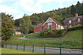
2
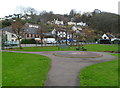
Houses overlooking the green at Redbrook
Image: © David Martin
Taken: 2 Apr 2022
0.01 miles
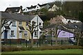
3
Wye's Green houses, Redbrook
Wye's Green is a row of 7 modern houses alongside the A466 Redbrook Road.
Viewed from railings at the edge of the village green.
Image: © Jaggery
Taken: 4 Dec 2011
0.01 miles
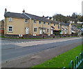
4

Post Office. Lower Redbrook
And local village stores.
Image: © Pauline E
Taken: 24 Oct 2008
0.02 miles
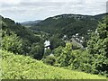
5
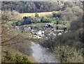
View over the river
Looking towards Redbrook from an elevated section of Lone Lane in the Welsh side at Penallt.
Image: © Jonathan Billinger
Taken: 20 Mar 2020
0.02 miles
6
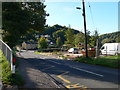
Entering Redbrook
Situated on an attractive stretch of the Wye, Redbrook was an important industrial centre with many industrial sites including mills, an iron furnace, tinplate works and copper works. The oldest site is the King's Mill, which was a corn mill first recorded in 1434 and remained in use until 1925. http://www.fweb.org.uk/Dean/towns/redbrook.htm
Image: © Eirian Evans
Taken: 25 Sep 2010
0.02 miles
7
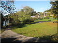
Lower Redbrook
To the fore, the Millennium Village Green, behind, the spire of St. Saviour's church, to the left the River Wye and the disused railway bridge. The Wye Valley Railway once ran through Redbrook. Opened in 1876 to connect Monmouth to the South Wales line, the railway closed to passengers in 1959 and the last freight train passed through in 1964. The bridge is now used as a footbridge.
Image: © Pauline E
Taken: 24 Oct 2008
0.02 miles
8
Cast iron logo in the village green, Redbrook
This logo http://www.geograph.org.uk/photo/1019535 is the centrepiece of the village green on the east bank of the River Wye.
Image: © Jaggery
Taken: 4 Dec 2011
0.02 miles
9
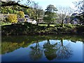
Trees reflected in the River Wye
Trees reflected in the River Wye at Redbrook.
Image: © Philip Halling
Taken: 2 Nov 2018
0.02 miles