IMAGES TAKEN NEAR TO
Redbrook, MONMOUTH, NP25 4LW
Introduction
This page details the photographs taken nearby to NP25 4LW by members of the Geograph project.
The Geograph project started in 2005 with the aim of publishing, organising and preserving representative images for every square kilometre of Great Britain, Ireland and the Isle of Man.

There are currently over 7.5m images from over14,400 individuals and you can help contribute to the project by visiting https://www.geograph.org.uk
Image Map (Loading...)


Getting Data...Please wait
Leaflet Map data © OpenStreetMap
Images are licensed for reuse under creativecommons.org/licenses/by-sa/2.0
Notes
- Clicking on the map will re-center to the selected point.
- The higher the marker number, the further away the image location is from the centre of the postcode.
Image Listing (74 Images Found)
Images are licensed for reuse under creativecommons.org/licenses/by-sa/2.0
Image
Details
Distance
1
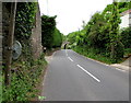
Two roadside mirrors, Redbrook
Alongside the road from Redbrook to Upper Redbrook, the grey back of one mirror is on a post. The other mirror, on the far side of the building, faces the camera. A disused railway bridge http://www.geograph.org.uk/photo/4491720 is in the background.
Image: © Jaggery
Taken: 25 May 2015
0.01 miles
2
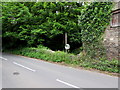
Visibility mirror on a post, Redbrook
One of two adjacent mirrors http://www.geograph.org.uk/photo/4491757 alongside the minor road from Redbrook to Upper Redbrook.
Image: © Jaggery
Taken: 25 May 2015
0.01 miles
3
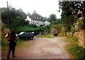
Redbrook
Dilyn Llwybr Clawdd Offa i gyfeiriad Redbrook Uchaf.
Following the Offa's Dyke Path in the direction of Upper Redbrook
Image: © Alan Richards
Taken: 20 Aug 1997
0.03 miles
4
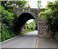
Old bridge in Redbrook, Glos
On a steepish incline.
Image: © Jeremy Bolwell
Taken: 17 Feb 2013
0.04 miles
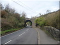
5
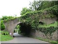
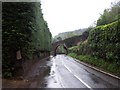
South side of a disused railway bridge, Redbrook
The bridge is over a minor road from Redbrook to Upper Redbrook and Newland.
Headroom (between the vertical markers on the bridge) is 11' 0"
Image: © Jaggery
Taken: 25 May 2015
0.04 miles
6
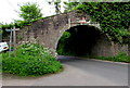
Redbrook - Incline Bridge
This 19th bridge once carried a horse-drawn tramway on the Redbrook Branch of the Monmouth Railway. This was then a tinplate-making village.
https://forestofdeanhistory.org.uk/learn-about-the-forest/redbrook-incline/
Image: © Colin Smith
Taken: 4 Aug 2023
0.04 miles
8
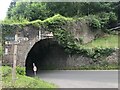
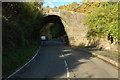
North side of a former railway bridge and Offa's Dyke Path, Redbrook
The bridge is over a minor road from Upper Redbrook to Redbrook.
Headroom (between the vertical markers on the bridge) is shown as 11' 0"
On the left, an Offa's Dyke Path signpost shows 12 miles to Chepstow, 3½ to Monmouth.
Image: © Jaggery
Taken: 25 May 2015
0.04 miles
9
Incline Bridge, Redbrook
Looking down the former B4231 from Newland towards the bridge that carried an incline colliery railway over the road - long disused
Image: © Chris Heaton
Taken: 8 May 2006
0.04 miles
10
Incline bridge, Redbrook
Former colliery railway bridge over the former B4231 at Redbrook.
Image: © Philip Halling
Taken: 30 Oct 2010
0.04 miles