IMAGES TAKEN NEAR TO
Tregare, MONMOUTH, NP25 4DT
Introduction
This page details the photographs taken nearby to NP25 4DT by members of the Geograph project.
The Geograph project started in 2005 with the aim of publishing, organising and preserving representative images for every square kilometre of Great Britain, Ireland and the Isle of Man.

There are currently over 7.5m images from over14,400 individuals and you can help contribute to the project by visiting https://www.geograph.org.uk
Image Map
Images are licensed for reuse under creativecommons.org/licenses/by-sa/2.0
Notes
- Clicking on the map will re-center to the selected point.
- The higher the marker number, the further away the image location is from the centre of the postcode.
Image Listing (6 Images Found)
Images are licensed for reuse under creativecommons.org/licenses/by-sa/2.0
Image
Details
Distance
1
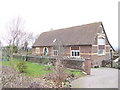
Old School House
Converted fairly recently and sympathetically.
Image: © Jonathan Billinger
Taken: 29 Jan 2007
0.03 miles
2
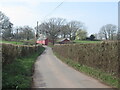
Waterloo, Coed-cefn
Name a hint to the age of the property.
Image: © Richard Webb
Taken: 21 Mar 2022
0.21 miles
3
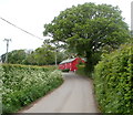
Waterloo Cottage, Coed-Cefn
The conspicuous cottage was formerly painted white.
Image: © Jaggery
Taken: 1 May 2011
0.21 miles
4
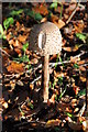
Fungus in woodland
Fungus in woodland in woodland beside a footpath near Pen-yr-Heol.
Image: © Philip Halling
Taken: 13 Nov 2011
0.21 miles
5

Waterloo Cottage, Coed-Cefn
Hard to miss!
Image: © Geoff Pick
Taken: 11 Aug 2010
0.22 miles
6
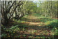
Footpath through a coppice
Footpath through a coppice near Pen-yr-Heol.
Image: © Philip Halling
Taken: 13 Nov 2011
0.22 miles