IMAGES TAKEN NEAR TO
Oakdale, MONMOUTH, NP25 4DS
Introduction
This page details the photographs taken nearby to Oakdale, NP25 4DS by members of the Geograph project.
The Geograph project started in 2005 with the aim of publishing, organising and preserving representative images for every square kilometre of Great Britain, Ireland and the Isle of Man.

There are currently over 7.5m images from over14,400 individuals and you can help contribute to the project by visiting https://www.geograph.org.uk
Image Map
Images are licensed for reuse under creativecommons.org/licenses/by-sa/2.0
Notes
- Clicking on the map will re-center to the selected point.
- The higher the marker number, the further away the image location is from the centre of the postcode.
Image Listing (7 Images Found)
Images are licensed for reuse under creativecommons.org/licenses/by-sa/2.0
Image
Details
Distance
1
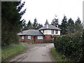
Oakdale
Park wood looms ominously behind the house.
Image: © Jonathan Billinger
Taken: 29 Jan 2007
0.02 miles
2
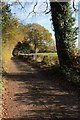
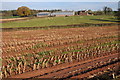
Lane at Pen-yr-Heol
An autumn lane near Pen-yr-Heol.
Image: © Philip Halling
Taken: 13 Nov 2011
0.10 miles
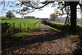
3
Farm road to Great Bailea Farm
Farm road to Great Bailea Farm and Lower Baileau Farm near Pen-yr-Heol.
Image: © Philip Halling
Taken: 13 Nov 2011
0.13 miles
4
Driveway to Llwyn-crwn
Farm driveway to Llwyn-crwn Farm near Pen-yr-Heol.
Image: © Philip Halling
Taken: 13 Nov 2011
0.16 miles
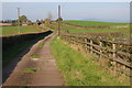
5
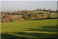
Farmland at Pen-yr-Heol
Rolling Monmouthshire farmland at Pen-yr-Heol.
Image: © Philip Halling
Taken: 13 Nov 2011
0.20 miles
6
Llwyn-crwn Farm
Llwyn-crwn Farm viewed from a passing footpath.
Image: © Philip Halling
Taken: 13 Nov 2011
0.24 miles
7
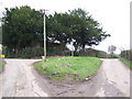
Lane junction at Pen-yr-heol
A fork in the road and a fine example of a grass triangle.
Image: © Jonathan Billinger
Taken: 29 Jan 2007
0.24 miles