IMAGES TAKEN NEAR TO
Dingestow, MONMOUTH, NP25 4BR
Introduction
This page details the photographs taken nearby to NP25 4BR by members of the Geograph project.
The Geograph project started in 2005 with the aim of publishing, organising and preserving representative images for every square kilometre of Great Britain, Ireland and the Isle of Man.

There are currently over 7.5m images from over14,400 individuals and you can help contribute to the project by visiting https://www.geograph.org.uk
Image Map
Images are licensed for reuse under creativecommons.org/licenses/by-sa/2.0
Notes
- Clicking on the map will re-center to the selected point.
- The higher the marker number, the further away the image location is from the centre of the postcode.
Image Listing (36 Images Found)
Images are licensed for reuse under creativecommons.org/licenses/by-sa/2.0
Image
Details
Distance
1
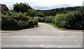
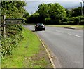
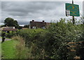
Minor road from Coed-y-fedw towards Pen-y-clawdd
Looking south across Groesenon Road in rural Monmouthshire.
Image: © Jaggery
Taken: 27 Aug 2018
0.02 miles
2
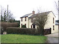
Cottage by Coed-y-fedw crossroads
Image: © Jonathan Billinger
Taken: 29 Jan 2007
0.02 miles
3
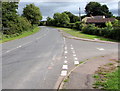
Junction in Coed-y-fedw, Monmouthshire
From the right (south) a minor road from Pen-y-clawdd joins Groesenon Road.
Ahead on Groesenon Road for Dingestow, Mitchel Troy and Monmouth.
Image: © Jaggery
Taken: 27 Aug 2018
0.02 miles
4
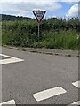
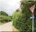
Misaligned GIVE WAY sign, Coed-y-fedw, Monmouthshire
In June 2024 the sign alongside a minor road is facing a main road.
It should be facing the opposite way.
Image: © Jaggery
Taken: 9 Jun 2024
0.02 miles
5
Pen-y-clawdd direction and distance sign in Coed-y-fedw, Monmouthshire
The sign alongside Groesenon Road points right (south) towards this https://www.geograph.org.uk/photo/5885518 minor road towards Pen-y-clawdd (or Penyclawdd) one mile away. Both locations are in rural Monmouthshire.
Image: © Jaggery
Taken: 27 Aug 2018
0.03 miles
6
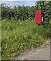
Queen Elizabeth II postbox on grass, Coed-y-fedw
Near crossroads in rural Monmouthshire.
Image: © Jaggery
Taken: 9 Jun 2024
0.03 miles
7
National Cycle Network route 423 direction sign in Coed-y-fedw, Monmouthshire
On the right here. https://www.geograph.org.uk/photo/5885602 The Sustrans website states that Route 423 follows the former Regional Route 30 and the Peregrine Path from Cwmbran to Ross-on-Wye via Monmouth.
Image: © Jaggery
Taken: 27 Aug 2018
0.04 miles
8
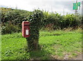
Queen Elizabeth II postbox in Coed-y-fedw, Monmouthshire
Alongside Groesenon Road near crossroads. A direction sign for Pen-y-clawdd Farm Fishery is on the right.
Image: © Jaggery
Taken: 27 Aug 2018
0.04 miles
9
Pen-y-clawdd Farm Fishery direction sign in Coed-y-fedw, Monmouthshire
The arrow on the sign on the south side of Groesenon Road points towards this https://www.geograph.org.uk/photo/5885518 road.
Image: © Jaggery
Taken: 27 Aug 2018
0.04 miles
10
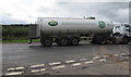
Arla milk tanker in Coed-y-fedw, Monmouthshire
Travelling westwards on Groesenon Road. Text on the vehicle includes BECAUSE WE ARE FARMER OWNED WE KNOW OUR MILK - EVERY STEP OF THE WAY FROM COW TO YOU.
Image: © Jaggery
Taken: 27 Aug 2018
0.04 miles