IMAGES TAKEN NEAR TO
Queens Hill, MONMOUTH, NP25 4BE
Introduction
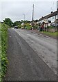
This page details the photographs taken nearby to Queens Hill, NP25 4BE by members of the Geograph project.
The Geograph project started in 2005 with the aim of publishing, organising and preserving representative images for every square kilometre of Great Britain, Ireland and the Isle of Man.

There are currently over 7.5m images from over14,400 individuals and you can help contribute to the project by visiting https://www.geograph.org.uk
Image Map
Images are licensed for reuse under creativecommons.org/licenses/by-sa/2.0
Notes
- Clicking on the map will re-center to the selected point.
- The higher the marker number, the further away the image location is from the centre of the postcode.
Image Listing (167 Images Found)
Images are licensed for reuse under creativecommons.org/licenses/by-sa/2.0
Image
Details
Distance
1
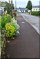
Yellow and white flowers, Dingestow
On the pavement beyond a house garden in June 2022.
Image: © Jaggery
Taken: 5 Jun 2022
0.01 miles
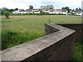
2
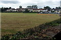
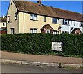
Field and houses, Dingestow
Looking towards the main residential part of the small village in rural Monmouthshire.
Image: © Jaggery
Taken: 17 Jul 2016
0.01 miles
3
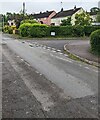
Queen's Hill, Dingestow
From the main road through Dingestow, Queen's Hill ascends towards Charles Road.
Image: © Jaggery
Taken: 5 Jun 2022
0.01 miles
4
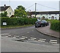
Junction in Dingestow
From the right, Queen's Hill descends to the main road through Dingestow.
Image: © Jaggery
Taken: 5 Jun 2022
0.02 miles
5
Road away from the centre of Dingestow
In rural Monmouthshire.
Image: © Jaggery
Taken: 5 Jun 2022
0.02 miles
6
Cold Calling Control Zone notice, Dingestow
The Trading Standards notice on the lamppost states that this area is a Cold Calling Control Zone and shows a number to phone if you are cold called. Cold calling is the contacting by businesses or their agents of people thought to be potential customers, without the contact having been prearranged.
Image: © Jaggery
Taken: 5 Jun 2022
0.02 miles
7
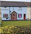
Union Flags on windows, Dingestow
Union Flags (Union Jacks) viewed on June 5th 2022 during Queen Elizabeth II's Platinum Jubilee celebrations nationwide.
Image: © Jaggery
Taken: 5 Jun 2022
0.02 miles
8
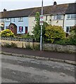
Queen's Hill name sign in a hedge, Dingestow, Monmouthshire
The sign facing the main road through the village shows that Queen's Hill
leads to The Bungalow and Charles Road. The text is also in Welsh.
Image: © Jaggery
Taken: 5 May 2024
0.02 miles
9
Green, pink, white and black
View of the south side of Dingestow from the bridge over the River Trothy.
Image: © Ian Paterson
Taken: 21 Jun 2011
0.02 miles
10

SE Dingestow houses
Houses in SE Dingestow, located alongside the main road through the village.
Viewed from near the River Trothy bridge. http://www.geograph.org.uk/photo/3126632
Image: © Jaggery
Taken: 1 May 2011
0.02 miles