IMAGES TAKEN NEAR TO
Tinmans Place, MONMOUTH, NP25 4AS
Introduction
This page details the photographs taken nearby to Tinmans Place, NP25 4AS by members of the Geograph project.
The Geograph project started in 2005 with the aim of publishing, organising and preserving representative images for every square kilometre of Great Britain, Ireland and the Isle of Man.

There are currently over 7.5m images from over14,400 individuals and you can help contribute to the project by visiting https://www.geograph.org.uk
Image Map
Images are licensed for reuse under creativecommons.org/licenses/by-sa/2.0
Notes
- Clicking on the map will re-center to the selected point.
- The higher the marker number, the further away the image location is from the centre of the postcode.
Image Listing (88 Images Found)
Images are licensed for reuse under creativecommons.org/licenses/by-sa/2.0
Image
Details
Distance
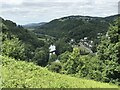
1
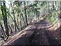
Byway through the woods above Lower Redbrook
Low late November sun is casting long shadows on this woodland byway above Redbrook.
Image: © Philip Halling
Taken: 23 Nov 2017
0.06 miles
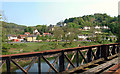
5
View over the river
Looking towards Redbrook from an elevated section of Lone Lane in the Welsh side at Penallt.
Image: © Jonathan Billinger
Taken: 20 Mar 2020
0.15 miles
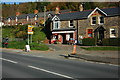
6

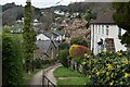
Post Office. Lower Redbrook
And local village stores.
Image: © Pauline E
Taken: 24 Oct 2008
0.16 miles
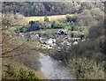
8
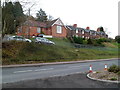
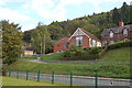
Village Hall and Wye View Terrace, Redbrook
Set back from and above the A466, the main road through Redbrook.
Image: © Jaggery
Taken: 4 Dec 2011
0.16 miles