1
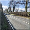
Monmouth Road towards Trellech, Monmouthshire
Looking south along the B4293 Monmouth Road.
Image: © Jaggery
Taken: 27 Feb 2022
0.07 miles
2
Logging road, Trellech Common
Image: © Richard Webb
Taken: 21 Mar 2022
0.07 miles
3
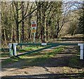
Into Trellech Common, Monmouthshire
Into a National Forest for Wales site from this https://www.geograph.org.uk/photo/7106511 barrier.
Image: © Jaggery
Taken: 27 Feb 2022
0.07 miles
4
Two signs near the entrance to Trellech Common
Located here. https://www.geograph.org.uk/photo/7106511
The upper sign shows "No motorcycles".
The lower sign shows "CCTV in operation".
The text on each sign is also in Welsh.
Image: © Jaggery
Taken: 27 Feb 2022
0.08 miles
5
Road into Trellech woods
Image: © Eirian Evans
Taken: 15 Feb 2011
0.08 miles
6
Barrier across the road into Trellech Common
National Forest for Wales site accessed from the B4293 Monmouth Road behind the camera.
Image: © Jaggery
Taken: 27 Feb 2022
0.08 miles
7
Wordless signs at the entrance to Trellech Common, Monmouthshire
Near this https://www.geograph.org.uk/photo/7106511 barrier at the entrance to a National Forest for Wales site in rural Monmouthshire.
Image: © Jaggery
Taken: 27 Feb 2022
0.08 miles
8
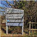
Trellech Common nameboard
Facing the B4293 Monmouth Road in rural Monmouthshire. Trellech Common is Comin Tryleg in Welsh. English text on the board in February 2022 includes "Natural Resources Wales" and "National Forest for Wales".
Image: © Jaggery
Taken: 27 Feb 2022
0.09 miles
9
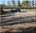
Parking area near Trellech Common, Monmouthshire
Located between the B4293 Monmouth Road and this https://www.geograph.org.uk/photo/7106511 barrier at the entrance to a National Forest for Wales site.
Image: © Jaggery
Taken: 27 Feb 2022
0.09 miles
10
Woodland, Trellech Common
A large area of forest which eventually descends steeply to the Wye.
Image: © Richard Webb
Taken: 21 Mar 2022
0.09 miles


