IMAGES TAKEN NEAR TO
Lydart, MONMOUTH, NP25 4AD
Introduction
This page details the photographs taken nearby to NP25 4AD by members of the Geograph project.
The Geograph project started in 2005 with the aim of publishing, organising and preserving representative images for every square kilometre of Great Britain, Ireland and the Isle of Man.

There are currently over 7.5m images from over14,400 individuals and you can help contribute to the project by visiting https://www.geograph.org.uk
Image Map
Images are licensed for reuse under creativecommons.org/licenses/by-sa/2.0
Notes
- Clicking on the map will re-center to the selected point.
- The higher the marker number, the further away the image location is from the centre of the postcode.
Image Listing (16 Images Found)
Images are licensed for reuse under creativecommons.org/licenses/by-sa/2.0
Image
Details
Distance
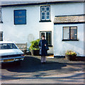
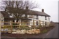
1
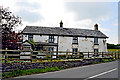
The Gockett Inn
My GGGrandparents were the Inn Keepers for the Gockett during the Mid to Late 1800's.
Image: © Paul Berndt
Taken: 24 May 2008
0.05 miles
2
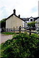
The Gockett Inn
My GGGrandparents were the Inn Keepers for the Gockett during the Mid to Late 1800's.
Image: © Paul Berndt
Taken: 24 May 2008
0.05 miles
3
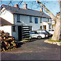
Gockett Inn, 1975
The Inn was still open as a Pub. My Aunt took this photo while visiting cousins. Although the roofline has been modified since this photo, the details are still the same in my 2008 images. My GGGrandparents were the Inn Keepers for the Gockett during the Mid to Late 1800's.
Image: © Patricia Woodcock Dirr
Taken: Unknown
0.05 miles
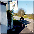
4
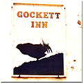
The Gockett Inn Sign, 1975
The Inn was still open as a Pub. My Aunt took this photo while visiting cousins. My GGGrandparents were the Inn Keepers for the Gockett during the Mid to Late 1800's.
Image: © Patricia Woodcock Dirr
Taken: Unknown
0.05 miles
5
The Gockett Inn, 1975
The Inn was still open as a Pub. My Aunt took this photo while visiting cousins. My GGGrandparents were the Inn Keepers for the Gockett during the Mid to Late 1800's.
Image: © Patricia Woodcock Dirr
Taken: Unknown
0.05 miles
6
The Gockett Inn, 1975
The Inn was still open as a Pub. My GGGrandparents were the Inn Keepers for the Gockett during the Mid to Late 1800's.
Image: © Patricia Woodcock Dirr
Taken: Unknown
0.05 miles
7
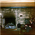
The Gockett Inn Hearth, 1975
The Inn was still open as a Pub. My GGGrandparents were the Inn Keepers for the Gockett during the Mid to Late 1800's.
Image: © Patricia Woodcock Dirr
Taken: Unknown
0.05 miles
8
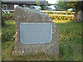
Five Trees Boundary Stone
"At this point the Parishes of Cwmcarvan, Mitchell Troy, Penallt and Trellech meet. Prior to 1800 four trees were planted to mark the junction and a fifth was placed in the middle as the central point. The Site was restored by Trellech United Community Council during 1982/83, with the assistance of young persons employed under the Youth Training Scheme"
Image: © Roy Parkhouse
Taken: 28 Mar 2000
0.07 miles
9
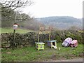
Egg stall, B4293
Where a road serving several properties meets the Monmouth to Trellech road.
Image: © Richard Webb
Taken: 21 Mar 2022
0.08 miles
10
A country inn - now sadly closed
This was The Gocket Inn which closed around 2003. The photographer delivered wine to this PH in the 1990's.
Image: © Jonathan Billinger
Taken: 27 Dec 2006
0.09 miles