IMAGES TAKEN NEAR TO
Agincourt Square, MONMOUTH, NP25 3UA
Introduction
This page details the photographs taken nearby to Agincourt Square, NP25 3UA by members of the Geograph project.
The Geograph project started in 2005 with the aim of publishing, organising and preserving representative images for every square kilometre of Great Britain, Ireland and the Isle of Man.

There are currently over 7.5m images from over14,400 individuals and you can help contribute to the project by visiting https://www.geograph.org.uk
Image Map
Images are licensed for reuse under creativecommons.org/licenses/by-sa/2.0
Notes
- Clicking on the map will re-center to the selected point.
- The higher the marker number, the further away the image location is from the centre of the postcode.
Image Listing (1091 Images Found)
Images are licensed for reuse under creativecommons.org/licenses/by-sa/2.0
Image
Details
Distance
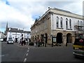
1
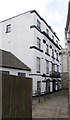
Haart estate agents, Beaufort Arms Court, Monmouth
The building is the Grade II (star) listed former Beaufort Arms hotel. The hotel was sold to a developer who converted the buildings into apartments and shops in 1989 and renamed the site Beaufort Arms Court.
Image: © Jaggery
Taken: 10 Jun 2018
0.00 miles
2
![Monmouth buildings [5]](https://s3.geograph.org.uk/geophotos/06/93/06/6930615_01c7f2cd_120x120.jpg)
Monmouth buildings [5]
Seen between the Shire Hall on the right and the former Bull Inn on the left is The Beaufort Arms, number 6 Agincourt Square. Built circa 1835 as a coaching inn, the building was converted into flats and shops in 1989. There is an extensive yard to the rear with a later wing. Constructed of stuccoed brick with a concealed roof. See also Image Listed, grade II*, with details at: https://cadwpublic-api.azurewebsites.net/reports/listedbuilding/FullReport?lang=&id=2227
Monmouth is a market town at the confluence of the Rivers Monnow and Wye some 30 miles northeast of Cardiff. Although there is evidence of settlement in the Neolithic period, the town was established around the Norman castle which was the birthplace of King Henry V. The historic county town of Monmouthshire, the town is now a centre for Wye Valley tourism.
Image: © Michael Dibb
Taken: 28 May 2021
0.00 miles
3
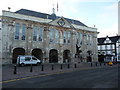
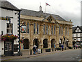
The Shire Hall in Monmouth
Now restored it's a magnificent building and worthy of any county town.
Image: © Jeremy Bolwell
Taken: 7 Sep 2010
0.01 miles
4
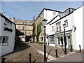
Henry's Cafe, Monmouth
This establishment in a courtyard off Agincourt Square is clearly in the Christmas mood.
Image: © Stephen McKay
Taken: 12 Dec 2016
0.01 miles
6
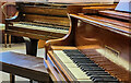
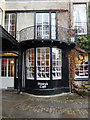
Piano shop, Monmouth
Unusual to find several old baby grand pianos in a second-hand shop in town.
Image: © Jonathan Billinger
Taken: 11 Dec 2021
0.01 miles
7
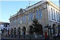
Monmouth Shirehall in early January 2012
Image: © Roger Davies
Taken: 2 Jan 2012
0.01 miles
8
Shire Hall, Monmouth
Built in 1724. It was used as a court house and the trial for treason of the Chartist John Frost (1840) took place there. He was found guilty of treason for his part in the Newport Rising. He was sentenced to be hanged drawn and quartered. This was commuted to transportation to Australia. See http://www.geograph.org.uk/photo/3900099 for other Chartist connections.
Image: © Bikeboy
Taken: 8 Apr 2014
0.01 miles
9
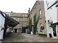
Beaufort Arms Court
Square behind the town hall, Monmouth.
Image: © Richard Webb
Taken: 20 Oct 2014
0.01 miles
10
The Shire Hall, Monmouth
The Shire Hall is a prominent Grade I listed building (http://www.britishlistedbuildings.co.uk/wa-2228-the-shire-hall-monmouth British Listed Buildings) in Agincourt Square in Monmouth town centre. It was built in 1724, and was formerly the centre for the Assize Courts and Quarter Sessions for Monmouthshire. It is currently used as a Tourist Information Centre and as the offices for Monmouth Town Council.
There is a sculpture of King Henry V, in a niche above the front entrance and below the clock and a statue of CS Rolls in the cobbled area to the front.
Image: © David Dixon
Taken: 27 Aug 2012
0.01 miles